Fairview Cemetery came into use in the early 18th century. The precise date of the first burial has not been determined but an early stone marking the grave of Abram Wright is reputed to bear the date 1702. During the Colonial Period, the appearance was that of a small cleared parcel of land occupied by slate markers with arched tops. Fairview retained this form until the late 19th century when, in imitation of Rural or Garden style cemeteries in many other Massachusetts communities, the local Commissioners of Public Cemeteries caused stone walls and gateways, plot plans and curving avenues to be created. This activity affirmed that Fairview would become the town’s principal place of burial.
Given its status as the town’s oldest, largest and most fashionable resting place, it attracted the leading industrialists, politicians, ministers as well as mill hands and farmers. The variety of personal backgrounds is matched by the variety of grave marker sizes and types. Large granite obelisks are found adjacent to diminutive marble tablets. Arched slate markers from knee height to six feet are present. A variety of other types is scattered throughout the cemetery.
Colonial and Federal Period slate markers, numbering in the hundreds, are well preserved and demonstrate typical artistic conventions and motifs such as death’s heads, portal designs and urns under willow trees. Markers from these periods are divided geographically from later examples by the difference in circulation patterns. Slate markers are placed amid a grassy section that continues to bear evidence of short glacial mounds of earth such as existed prior to centuries of plowing and grading. No avenues exist between stones in this area. These occupy a central rectangular area, known as the Old Division, that abuts Main Street.
Victorian Period gravestones are mostly carved from granite, a locally quarried material. Standard forms such as tablets and chests exist along with unusual examples such as a millstone and a sphere. A single monumental bronze example has been identified. Plots from this period are frequently delineated with curbs and corner posts. Nearly a dozen gravestone carvers, some with several markers to their credit, have been identified.
In addition to occasionally ornate grave markers, some sections of Fairview have winding paths and avenues to provide access to plots. Ground in this area has been graded to reflect gradual changes in elevation. Mounds have been removed to accommodate circulation paths and organization of plots. These changes came in response to trends in cemetery design promoting the picturesque, part of which consisted of renaming the former East Burying Ground to Fairview Cemetery in 1904. The curvilinear portion, known as the East Division was added in 1876. Additional land was again added in 1924 (New Division) and in 1936 (Tadmuck Division). The cemetery continues in use today, but has run out of plots to sell.
The 18th century appearance of the East Burying Ground was that of a grassy half-acre parcel of short rolling mounds occupied by arched slate gravestones. Located immediately south of Main Street and one mile east of the town center and meetinghouse, the burial ground was mowed and its volunteer growth of bushes trimmed as if it were a farm field. Nineteenth century structures include tombs in the center of the burial ground on two sides of a low earthen mound and two tombs built into the stone wall that lines Main Street. Ornamental trees planted on the grounds include maples, oaks, hemlocks and a variety of evergreen species. Nineteenth century efforts to improve the appearance of the burial ground by grading and constructing avenues among the stones encompassed land on three sides of the Colonial Period burials. A short embankment distinguishes between the rolling mounds of un-tilled earth around earlier burials and the more gradual changes in elevation that were the result of attempts to create a Garden style cemetery.
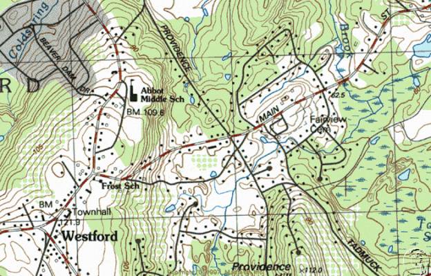
Stone walls separate the cemetery from Main Street and from Tadmuck Road. The most refined in materials and design is the segment from the corner of the two roads heading east to the main gateway. This is coursed granite ashlar construction three to four feet in height with flat capstone. From the main entrance to the eastern end of the Main Street side is a similar granite ashlar wall of older, uncoursed construction and a similar capstone. The entire wall is approximately 1000’ long. The Tadmuck Road side of Fairview Cemetery is lined with approximately 500’ of two to four foot high cobblestone wall with concrete cap. The rear or south boundary of the cemetery is lined with dry-laid fieldstone that may have been built as part of an adjacent farm field boundary.
The cemetery acquired some refinements in appearance with construction of stone gateways on both the Main Street and Tadmuck Road sides. Most prominent is the main gateway halfway along the Main Street side. Here, two coursed ashlar granite walls curve into the cemetery and toward each other in 90-degree arcs ending in square nine-foot high pillars with square capstones. Secondary pillars mark the departure of the curved sections from the main wall. The corner access at Main Street and Tadmuck Road has a similar arrangement of pillars without the curving wall segments. Both have stones in one pillar bearing the name “Fairview.” The Tadmuck Road entrance is flanked by two round pillars built of cobblestone to a height of seven feet. The eastern end of the Main Street side has an unornamented secondary access through the ashlar granite wall for vehicles that is unornamented. A flight of three narrow steps is built into the Main Street wall near the mid-way point.
Circulation among plots is guided in the eastern and western sections of the cemetery by a system of asphalt paths or avenues, ten feet in width. The more picturesque curvilinear avenues emanate from the secondary Main Street entrance. Diverging to the east and west, paths follow a winding course toward the south and meet near the rear of the parcel, encompassing the 19th century addition to the East Burying Ground. A central winding route nearly bisects these paths around the perimeter. The 1876 plan of this section of the cemetery grounds reflects among these avenues several narrower paths that may have once existed as dirt surfaced footpaths but are now planted in grass and of uncertain direction. The principal gateway on Main Street gives onto two straight parallel avenues heading directly to the rear of the cemetery with a transverse avenue gradually curving to the east and connecting to the more picturesque section of the circulation network. The central 18th century section of the cemetery has no paths between markers. Newer sections of the cemetery in the west and south also have asphalt avenues that are mostly straight except for a loop in the northwest corner, site of current burials. While not consistently apparent, a small number of curbs and low piers mark some edges and corners. The most ornate is close to the secondary entrance from Main Street and has a granite ball and curbstones marking the corner of two converging paths.
Plots in Fairview are delineated in some cases with granite curbstones. These are alternatively flush with the ground or elevated up to a foot above grade. In some cases, such as the Abbot - Cameron plot, the front is lined with stones near grade level while granite slabs at the rear of the plot act as a three-foot high retaining wall, thereby leveling the plot on its sloping site. A single iron fence remains in existence at the Thomas and Edmund Symmes plot. Ornate pales with pointed ends are connected by filigree and low granite posts to enclose an area of approximately eight by ten feet. It is likely that there were at one time many more such plot defining fences but that they have been removed to ease the chore of mowing.
Three tombs exist in Fairview, two of which are incorporated into the Main Street wall. The Town Tomb, marked as such on the 1938 cemetery plan but not so on the actual structure, has a low pedimented slab of granite rising slightly above the level of the wall. Two stout vertical slabs of granite flank the central iron door. Adjacent to the Town Tomb on the east is the Solomon Richardson family tomb, marked with a slate tablet that names nine family members interred from 1817 to 1902 and is set into the granite entry. The only tomb inside the boundaries of the cemetery contains five families: Heywood, Keyes, Proctor, Fletcher and Abbot. The low mound of earth at the south end of the 18th century section has tablets for two families on the east side and three on the north. Dates of these interments range from 1816 to 1926. Construction of doors is primarily granite with some inset slate tablets carved with names and dates. Modern granite tablets with names and dates have been added posthumously during the 20th century to the Abbot marker.
Two buildings exist in the southwest corner near Tadmuck Road. The former Hearse House, also called a tool house on the 1938 plan and now used as the superintendent’s office, is a one-story, side-gabled frame building sheathed in wood clapboards. The plan is two by two bays. Architectural ornament includes gable returns, corner boards and molded trim at the eaves. Modern windows have been installed. The outline of a vehicle door exists on the west elevation, which backs up to the cobblestone wall along Tadmuck Road. The proximity of the door to the wall now prevents vehicles from entering and suggests either that the building was moved or the wall was built after the need for the door was obviated. A shed ell expands the rear of the plan. A modern gabled shed or storage building is oriented perpendicular and immediately adjacent to the former hearse house. Three overhead doors on the east elevation provide access to the interior of the shed.
An open, wood-framed octagonal building with octahedral roof, approximately ten feet across and 12 feet high, is described in town reports at the time of construction as the “Summer House.” Turned posts with jigsawn brackets support the roof. A jigsawn baluster and benches on seven sides rim the floor. A pointed brass finial occupies the peak of the roof.
Fairview Cemetery reflects trends in gravestone development in its variety of slate, sandstone and granite markers. Slate is the oldest surviving material used for marking burials and is carved in arched, shouldered-arched and flat-topped tablets. Ranging in height from one foot to over five feet, this type of marker can demonstrate a relatively crude, hand cut appearance, a well-designed and possibly machine cut sharpness and several levels of workmanship in between.
Quality of workmanship of the slate marker is sometimes obscured by the fact that the stone has deteriorated or been broken. Inscriptions also vary in quality and detail. The simplest have fine, narrow letters with little relief or depth. Some of this type are well organized and clearly laid out. Others are jumbled in the way words are divided among lines. Later slate stones from the 19th century are more likely to demonstrate clear, deep, stylized letters with a pronounced serif and well thought out organization relative to the shape of the stone.
Markers appear in a variety of shapes. Those from the earliest period are most commonly cut in a rectangular form with an arched top, representative of the figurative portal between life and death. The shape is also considered an abstraction of the human head and shoulders. This form of marking the passage from life is a Puritan concept brought from Boston and elsewhere during the region’s period of first settlement. Eighteenth century stones are typically carved with one of a variety of motifs. The earliest marker in Fairview, thought to be that of Abram Wright from 1702, is unidentified. Other early stones have faces inscribed in portals, such as the 1783 slate marker of Ephraim Hildreth. Representative of the spirit of the deceased glancing back into the world of the living while simultaneously offering the living a preview of the afterlife, the portal is rich in Puritan symbolism and attitudes toward the transcendent nature of death. In addition to the portal are rows of diamond trim at the edges of the marker.
The symbol of winged death, in the form of either a skull or abstracted human head flanked by a pair of feathered wings spread wide, occurs frequently on stones carved in the late 18th century. This is another representation of the belief that the human spirit was released at the time of death for the flight heavenward. An example of this design motif is found on the double arched stone of brothers Ezekiel and Timothy Hildreth, who died in 1747 before they turned three years old, possibly because of small pox. They are remembered by a double-arched stone with floral trim and a pair of death’s heads flanked by wings and decorative circles. Circles figure prominently in the design of the slate marker for William Chandler who died in 1757 at the age of 67. Here, the winged skull is sited below the legend “momento mori”, a reminder to the living observers of their impending deaths. At the peak of the arched stone and above all other design features, are three concentric circles that symbolize eternal life and resurrection. Deacon Paul Fletcher, who died in 1735 at the age of 57, is buried beneath a stone with a death’s head, circles and flowers but without wings.
Based on classical influences exerted by the spreading glow of the Enlightenment, new images for gravestone ornamentation rapidly made the older themes seem outdated. Urn and willow designs appear frequently on gravestones from the Federal through the Victorian Period. Both slate and sandstone markers exhibit this late 18th and early 19th century motif that is an icon of sorrow and grief. A sculptural granite example also exists. Change from the puritan death’s head to the classically inspired urn and willow marked a change in the way death was viewed by New England society. Previously, the event was considered a common reality whose dim portent reflected the stern view of life as a struggle for survival. The Post-Puritan view of death adopted a sentimental quality that spoke more of the emotional state of those left behind than of the journey of the deceased, causing the replacement of darkly spiritual carvings with abstract sorrowful imagery. The use of columns in gravestone design, frequently of the Doric order, is evidence of the pervasive influence of imagery popularized by publications and designs featuring drawings of classical architecture. Major Jonathan Minot’s 1806 slate marker has an urn and willow design in its arched top with Doric columns flanking a central panel for the inscription.
A marker type with one example in Fairview is the tablestone used to mark the grave of the Reverend Willard Hall. Here, three vertical granite slabs support a horizontal slate slab inscribed with Reverend Hall’s dates and commemoration of his service to the First Church of Christ in Westford. The grave is also marked by a cast iron Maltese cross placed by the Sons of the American Revolution. The British flag identifies the minister as a Tory.
Additional marker types in the form of obelisks, chests, and tablets with biblical and classical symbolism appeared during the Victorian Period. Obelisks are carved mainly from granite although several early sandstone examples are present. This type of marker was in frequent use from the mid 19th century forward and ranges from six to 15 feet tall. The most prominent example, marking the burial site of the family of John William Pitt Abbot, is carved of pink granite. Its polished facets are inscribed near the base with dates for Mr. Abbot, his wife and three children. This is the largest monument in Fairview. Numerous other obelisks are from the late 1800s and have capstones and smooth, polished granite faces.
Chest markers appear throughout the cemetery with dates from the mid 1800s to the present. These are larger than tablets and are most frequently cut from granite. The William E. Frost (1842-1904) chest marker is an unornamented rectangle with polished front and rear faces. Edges of the marker have a rough quarry-faced finish. The Albert P. Richardson (1843-1903) chest marker, however, has all faces polished smooth and is trimmed with a floral motif and ovolo molding at the top.
Tablets with biblical symbolism appear, usually in marble. A poignant example is that of Agnes Cameron who died eight days after her birth in 1865. She is remembered with a small white marker topped with a lamb, symbol of youth and innocence.
Some non-traditional marker types appear in Fairview. Along the northern boundary of the cemetery is the marker for the mill owner George Heywood (1829-1914) and his family. The inscription appears in the polished circular face of a granite millstone. The rear of the marker has grooves as in an actual grindstone and may have been taken from the Heywood mill located at the crossing of Depot Street over the former Stony Brook Railroad (now CSX). The Griffin family marker is unusually large and has the cemetery’s only spherical ornament. Made of polished pink granite and resting on a stout pier and gray granite base, the sphere measures approximately three feet in diameter. The marker commemorates the lives of Joseph B. Griffin (1816-1896), his wives Deborah (1807-1848) and Eliza (1835-1912) and three other family members.
A single example of a zinc grave marker exists in Fairview and commemorates the Charles J. Searles (1836-1901) family. This unusual marker is the product of the Monumental Bronze Company of Bridgeport, Connecticut, which operated from the 1870s until after WW I. The three-foot high imitation stone is made to resemble quarry-faced granite in the form of a shortened obelisk. The top is ornamented by a rounded finial above a flared molding and hollow shaft. Below the shaft, the base flares in four-peaked fascia, the southerly of which bears the family names. This is the only known zinc monument in Fairview Cemetery but they are commonly found in cemeteries across the nation.
Military markers in Fairview are scattered throughout the cemetery. Charles Brooks is buried beneath a typical low arched marble tablet inscribed with the military unit with which he fought in the Spanish American War. Similar markers appear for veterans of the Civil and World Wars. Soldiers involved in actions prior to the Civil War are remembered by their ranks inscribed with their names, usually on slate markers. Many military markers are redundant, located adjacent to family stones that repeat dates for veterans.
The earliest known gravestone carver’s name to appear is that of I. Hartwell who carved a marble marker for Horace Parker, MD in 1829. Later stones bear carvers’ names and locations such as F. A. Brown of Derry, New Hampshire and A. Stone of Groton. B. Day, Charles Wheeler, T. Warren and D. Nichols, Gumb Bros. all had workshops in Lowell. Such evidence suggests this industrial center to the east was the primary community for buying items not available locally such as gravestones and other manufactured goods. The J. W. P. Abbot obelisk bears the inscription A. MacDonald Field & Co. Aberdeen.
Fairview has evolved into a modified rectangle and is currently known by four Divisions. The Old Division West occupies the center of the plan and abuts Main Street at the north. The East Division is recognizable by its curvilinear path network drawn in the 1870s by Edward Symmes. The New Division comprises a narrow rectangle at the south and was added in 1924. The Tadmuck Division, added in 1936 and landscaped between 1938 and 1953, occupies the west end of the overall plan. While records do not indicate as much, it is possible that, since few remain, footstones were removed as part of past efforts to tidy the grounds. Repairs have been carried out in the cemetery on a regular basis since the 19th century, resulting in visible repairs to some slate stones. Since the material is particularly susceptible to cracking and toppling, several different methods have been used to stabilize markers. There are some which have been re-set in concrete footings poured at ground level. Others have been re-attached at severed points with metal braces and bolts or cemented or glued across fractures. Most stones remain in good to excellent condition, although some slate markers are difficult to read due to erosion. The Cameron family marker appears originally to have had a finial which is now missing. While very little other vandalism has taken place, damage has been sustained in many cases due to scraping by lawn-mowing equipment. However, the large number of remaining 18th and 19th century markers make it possible to get a clear sense of historical burial and gravestone carving techniques in Westford.
Originally called the East Burying Ground (also called Snow’s after the former groundskeeper and neighbor Levi Snow), Westford’s first place of burial came into use before the founding of the town in 1729. While still considered Chelmsford’s West Precinct, Abram Wright was interred here in 1702. This is the earliest recorded burial although there were likely previous occupants. The record for Mr. Wright appears in the 1883 town history written by Edwin Hodgman who claims to have examined all existing markers. This occurred at a time when far more of the inscriptions were legible than is the case today due to erosion and other types of damage. Mr. Hodgman’s usually exacting efforts to reveal town or precinct records for establishment of the burial ground were fruitless. The 1702 stone is unidentified.
Bounds of the burial ground were found in 1753 by a committee chosen for the purpose at town meeting. It appears that even at that time, much of the origins were unclear. After agreeing upon property lines in relation to surrounding farmland, the committee lost little time in erecting a gate and horse mounting block, neither of which are evident today. Adjacent landowners Thomas Cummings and Josiah Brooks donated to the town in 1768 parcels for expanding the grounds by 18 rods to the south and an additional 30 rods in an undetermined direction.
Occupants of the East Burying Ground from the period include the town’s first mill owner, William Chandler (d. 1756, 67 years of age) who operated a fulling mill on Stony Brook near the current Brookside Road, Deacon Paul Fletcher who was chosen as such on January 5, 1733 and who died just two years later at the age of 57, Joseph Underwood (1681-1761) who was responsible for the sale to the town in 1748 of the parcel of land that became the Common, Deacon John Abbot (1713-1791) who was a selectman, school teacher, town clerk and progenitor of a leading family of industrialists, Reverend Willard Hall (d. 1779) who was the Tory minister of the First Parish Church from 1729-1775.
Revolutionary War veterans who fought in the Battle of Concord in April 1775 and were recognized by the Sons of the American Revolution with iron cross markers in 1902 include First Lieutenant Zaccheus Wright (later Captain at the Battle of White Plains, NY), Sergeant William Hildreth, Corporal Hosea Hildreth and Sergeant Major Jonathan Parker who also fought at Bunker Hill.
Less well-known residents tell of other aspects of the town’s history. Ezekiel and Timothy Hildreth share a double arched slate marker. Children of Abigail and Joseph Hildreth aged under three years, they both died in January 1747. This and other examples in Fairview of the loss of multiple children remind modern visitors of the hardships of Colonial life. Approximately 300 Colonial Period slate markers occupy the central part of the cemetery. The North and West Burying Grounds (now called Hillside and Westlawn) were in use by this time. These are smaller than Fairview and occupy sites farther from Westford Center.
The transformation from burial ground to the local version of a Rural style cemetery began nearly ten years after the founding in 1831 of Mount Auburn Cemetery in Cambridge. Nationally influential for its landscape designed by horticulturists and landscape architects and its governing body’s intention to beautify the final resting place, Mount Auburn served as a model to cemetery commissions across the country. Over a period of nearly 40 years, Westford’s cemetery commissioners would gradually create a simple version of a Rural cemetery by building walls, grading circulation paths and planting trees and shrubs.
The 1840 town report indicates the stone cutter and Westford resident Nathan S. Hamblin was paid $90 for building a wall and setting stone posts. In the same year, B. F. Keyes was paid for building and painting a fence. No evidence remains of a fence from the period but some portion of the stone wall lining Main Street from the main gateway to the northeastern corner is likely the work of Mr. Hamblin. Levi Snow was paid in 1858 for laying 24 ½ rods of wall (392 feet) which may have been the un-coursed granite section at the east end of the Main Street side. Asia Nutting was paid $101.50 for unspecified stone work in 1868. In 1880 the selectmen reported in favor of building a faced stone wall and began advertising for construction proposals, finally selecting that of George Yapp who lived three miles away on Concord Road near Hildreth Street. By 1883, Mr. Yapp had built the western 580’ feet of wall along Main Street using material quarried in Graniteville, thus completing the 1000’ of granite wall now extant. No mention is made at this time of the granite gateways but they were likely built at this time.
A new hearse house was built in 1870 by George Drew. This is likely the existing Superintendent’s Office at the southwest corner of the cemetery. Given the expansion of the grounds, the former hearse house has probably been moved so as to remain in a remote corner as the cemetery expanded. Town reports note that Mr. Hamblin was paid in 1871 for constructing the Town Tomb built into the Main Street wall. The first mention of the tomb appears in cemetery records on February 12, 1871. Prior to its construction, people who died during months when digging was impossible were temporarily interred in private tombs of other townspeople.
Cemetery commissioners acquired appropriations for another method of improving the appearance which involved re-setting older gravestones, presumably to put upright those that were leaning or had fallen. Colonial Period stones are now arranged in neat rows, oriented north to south, with most family members close together. The current absence of footstones may have come about as a result of this effort to tidy the grounds. Commissioners not only improved the burial ground’s appearance in these years but bought 38 rods of land from Joseph Henry Read in 1874 in order to expand the space available for burials.
The purchase of additional space and the community will to improve the burial ground led to a survey of the land in 1876. Locally prominent civil engineer Edward Symmes, a Fairview occupant who lived from 1806-1888, was retained to create a plan in a style fitting a Garden cemetery. Mr. Symmes also created the 1855 map of Westford. The result of the 1876 survey is the existing network of curvilinear paths and individual plots in the East Division. Water features were an integral part of Garden style cemetery planning for their ability to encourage reflection and to impart a sense of calm. Mr. Symmes appears to have intended a fountain to be built in a circular plot near the center of the cemetery, which, by the time of the 1938 cemetery plan, had been precluded by the plot’s use for a burial.
An important aspect of the process of transforming the East Burying Ground into the local version of a Garden style cemetery was that of deciding upon a new name. There were “many ladies” who, at the invitation of the cemetery commissioners, signed a petition in 1896 suggesting the name Fairview. The petition was immediately granted.
In addition to the creation of picturesque paths and avenues, cemetery commissioners created in 1894 a procedure for residents to reserve lots and either to pay the town one or two dollars annually for maintaining them or to establish a perpetual care fund in the amount of $50 to $100, the interest of which would pay for labor to trim shrubs and mow grass. Interest in establishing such funds was intense for the subsequent five years as can be seen in the legend “Perpetual Care” carved on many markers from the period.
A campaign of tree planting was begun in 1895 which continued for many years. Maples, red cedar, spruce and hardy shrubs were set out. Ornamental plantings continue to be an integral part of the designed landscape although few examples have survived from the late 19th century. The final addition to the cemetery during the period of refinement was the octagonal Summer House. The open-walled building was designed and built in 1896 by local carpenter William Edwards who was responsible for many other Westford buildings such as the 1870 Town Hall and the 1895 J. V. Fletcher Library.
Westford Residents interred at Fairview during the 19th century include the full range of economic, educational and social backgrounds. Indeed, nearly all burials taking place in the town by the end of the period occurred in Fairview due largely to its improved landscape. John William Pitt Abbot, Esq. (1806-1872) is buried with his family on a plot distinguished by the tallest marker in the cemetery. Mr. Abbot’s prominence in the community stemmed from his practice of law, title of president of the Stony Brook Railroad, involvement in the family industry of woolen manufacture in Graniteville and Forge Village, service to the town as selectman, town clerk and Westford Academy Trustee, service to the church as clerk for 40 years, and to the commonwealth as representative and senator. George R. Moore (1817-1892) is another mill owner buried in Fairview. He owned a number of companies in Chelmsford and the woolen yarn mill in the village of Brookside in Westford. Another resident of Fairview is Luther Wilkins, a farmer who lived with his wife and four children on the edge of the village of Westford Center. Mr. Wilkins’ son Luther E. Wilkins served in the Union Army in the Civil War. Other residents from the period include the town physician Dr. Benjamin Osgood who died in 1863 and Ira Leland (b. 1798), a butcher and farmer from Westford Center.
The cemetery had only a few groundskeepers during this period. From 1835 until his death in 1869 it was the farmer Levi Snow, who lived across the street and for whom the burial ground was occasionally called prior to its being renamed Fairview. His son George Snow performed the duty for two years until Samuel M. Hutchins took responsibility in 1871 and kept it until 1893. Mr. Hutchins occupied the house across Main Street from the cemetery after Levi Snow. Albert P. Richardson was the town’s Cemetery Superintendent and maintained Fairview into the 20th century until the time of his death in 1902.
Two parcels of adjacent land were added during the early 20th century to the cemetery’s southern boundary. The first was in 1924 and is now called the New Division. In this narrow rectangle, circulation paths adhere more closely to a grid pattern. Another parcel was added in 1936 to the western boundary abutting Tadmuck Road. A plan of the parcel from that year shows it outlined with dry-laid fieldstone walls such as a farmer might build to clear the land. Town reports from the years of the Great Depression contain sections that describe work done by members of the Works Progress Administration (W.P.A.). The W.P.A. report for 1938 discusses stone wall construction that was planned to enclose two sides of the cemetery, suggesting the existing cobblestone wall was W.P.A. work performed at that time.
Family members and friends of those interred established numerous trust funds to pay for maintaining plots. Markers are carved with the legend “Perpetual Care” as a way to notify groundskeepers of which plots get constant attention. The words may also have been a notice to passersby that the occupant enjoyed a certain level of status among cemetery residents. Costs for reserving burial plots during this period was two to five dollars. Perpetual care required the establishment of a trust fund, usually around $100. It appears from names printed on gravestones that, while a handful of people with apparently Irish surnames were buried in the 19th century, there were very few non-English occupants of Fairview until after the addition of the New Division in 1924.
Markers were placed in 1902 at the graves of Revolutionary War veterans by the patriotic and historical organization Sons of the American Revolution. Westford veterans who had been at the Battle of Concord received the S.A.R. emblem, an iron Maltese cross with an image of Daniel Chester French’s sculpture entitled The Minute Man. A Soldiers’ Lot, established in 1906, was reserved for veterans of the Civil War. In 1909, the town received from the United States Government six stones for marking graves of Civil War veterans. These are marble with low arched tops.
A small section exists on the 1938 plan of the cemetery labeled “Strangers’ Row”. The 1876 version of the plot plan of Fairview makes no mention of this parcel and was probably reserved for the indigent or for those simply with no family nearby. The plot is approximately 15’ by 30’ and has no markers however a total of 14 people were buried in the plot from 1907-1939. Sadly three of these are listed in cemetery records as “Unknown”.
Residents of Westford from the period who had an impact on town history and who occupy Fairview Cemetery include an array of industrialists, town officials, farmers and politicians. As in all other periods, members of the Abbot family of woolen mill owners were interred here. Several generations of this family were responsible for building the mills and much of the neighborhood of Graniteville and Forge Village with their side streets of worker housing. Adjacent to the J. W. P. Abbot family marker is that of Allan Cameron (1822-1900), a Scottish immigrant who worked first as a machinist and later operated a woolen yarn manufacturing concern. Mr. Cameron is the namesake of a former public grade school in Forge Village and was a family friend and business associate of the Abbots. George Heywood (1829-1914) was also an industrialist but on a smaller scale. He operated a grist mill at the Depot Street crossing of Stony Brook in the second half of the 19th century. Mr. Cameron and Mr. Heywood were commissioners of public burial grounds from 1892 to 1897. Frank Furbush (1861-1940) owned a gas station and auto repair shop in the village of Graniteville in 1921. In addition to his work on cars, Mr. Furbush acted as a manager at the woolen machinery manufacturing firm C. G. Sargent and Sons in Graniteville.
William E. Frost (1842-1904) was a very active public servant and is interred in Fairview. Mr. Frost worked as preceptor of Westford Academy from 1872 to 1904, and was namesake of the William E. Frost School on Main Street. He was educated at Bowdoin College and is said to have brought modern educational practices to Westford Academy. He was involved in the management of the J. V. Fletcher Library, and was a commissioner of public burial grounds from 1892 to 1897. Albert P. Richardson (d. 1902) was cemetery commissioner and caretaker of Fairview Cemetery. Farmers occupy many plots in Fairview. Oren Coolidge (1800-1872) who lived at 17 Forge Village Road for many years is interred here. Wayland Balch (1839-1937), the latest living Civil War Veteran from Westford, occupied farm houses at 24 Boston Road and 246 Concord Road during the late 19th century. He found his final resting place in Fairview.
Politicians of some note are interred here. Herbert Ellery Fletcher (1862-1956) occupies, with his wife Christina (1846-1912) and her family a granite above-ground tomb probably built with material taken from Mr. Fletcher’s quarry. In addition to operating the town’s largest granite quarry and a successful construction concern, Mr. Fletcher served in the state senate from 1901-1903, performed duties as delegate to the 1916 Republican National convention, and served in the Massachusetts General Court. He was a graduate of Westford Academy. Joseph Henry Read, (d. 1901) also a politician, served in local and state government and was a native of the town. He graduated from Westford Academy in 1855 and went on to become selectman, school committee member, county commissioner and a representative to the Massachusetts State Legislature.
Nettie Stevens (1861-1912) is distinguished among those at Fairview by virtue of her outstanding accomplishments in the field of biology. After studying at Westfield Normal School and completing the course of study in half the usual time, Ms. Stevens took a job teaching at Westford Academy from 1885 - 1892. She then attended Stanford University, graduating with a M.A. in 1900, and Bryn Mawr, teaching and earning a Ph.D. in 1903. The daughter of a local carpenter and graduate of Westford Academy, she died prematurely at Johns Hopkins University Hospital due to a fall in 1912.
Lieut. William Metcalf (1819-1900), who is interred in Fairview, was a Civil War Veteran and native of England. Mr. Metcalf worked as a mechanic, served in the 16th Massachusetts Infantry and lived near the corner of Boston and Littleton Roads. He was remembered after his death in 1900 by his son who commissioned the Metcalf Civil War Memorial, a bronze statue in Westford Center dedicated in 1910 to all Civil War veterans from the town.
Non-Anglo names appear in increasing numbers during this period. While many Irish, English, Russian and Polish immigrants worked in factories in the town starting in the 1850s, Fairview seems to have been favored by members of long-established Westford families. Those with surnames not of English extraction, such as O’Brien and Walkovich begin to appear in the parcel of land added to the cemetery in 1924.
The history and development of the East Burying Ground, renamed Fairview Cemetery in 1896, follow a path similar to many other cemeteries in New England. As in other communities, Fairview began during the 18th century as a cleared but otherwise unimproved parcel dedicated to burial of town residents. Major changes occurred as a result of 19th century trends in landscape design. These trends combined with the spirit of community involvement as seen in the numerous fraternal and social organizations of the time as well as the desire among rural residents to imitate more stylish urban examples of houses, dress, cemeteries and other aspects of life, combined to guide the will of Westford residents to create Fairview Cemetery.
Fairview Cemetery comprises all of the land within the boundaries of the cemetery. It is bounded by Main Street on the north and by properties on Fairview Drive on the south and east. Tadmuck Road forms the western boundary. The cemetery encompasses 10.45 acres, described by the assessor’s office as parcel 170 on map 27.
Boundaries of the cemetery were determined by the Westford Historical Commission and by the consultant. Boundaries include all gravestones, burial-related buildings, structures, circulation paths and ornamental plantings. Stone walls encircle the cemetery and mark all boundaries.
SKETCH MAP NORTH
TOWARD TOP
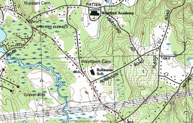
While the name Westlawn Cemetery implies existence of characteristics of the Rural Cemetery movement inspired by construction of Mount Auburn Cemetery in Cambridge, the landscape layout, appearance and gravestone art of the burial ground adhere more closely to design characteristics from the Colonial Period. Acquired from local farmers by the town as a burial ground in 1761, it was originally called the West Burying Ground. Many of those interred here are significant in the history of the Town of Westford. War veterans, mill owners and operatives, farmers and business people occupy the approximately 400 visible burials. Members of the Robinson, Prescott, Day, Fletcher and other families influenced the town’s history and appearance and continue to do so by virtue of their artfully carved gravestones.
Markers are made primarily from slate although many granite, sandstone and marble examples are present. Colonial and Federal Period grave markers appear in the form of arched, shouldered-arched and flat-topped tablets, the largest of which belongs to Colonel John Robinson, leader of Westford minutemen at the Battle of Concord on April 19, 1775. While Colonel Robinson’s slate marker has a refined urn and willow motif in its arched top, other slate markers have more primitive designs of death’s heads, faces inside portals and winged skulls.
Monuments from the Victorian Period take the form of obelisks and chests as well as tablets. Slate continued to be used after the Federal Period although marble and granite became more common. The Carver family chest marker was carved in the late 19th century from brown granite and placed atop an earthen mound near the western corner of the cemetery. This is one of Westlawn’s larger and more ornate markers and represents a departure from the simpler tablet form. It was probably during this time that residents placed granite curbs and low corner stones around the perimeters of some plots.
Grave markers are arranged in rows oriented east to west with inscriptions on older stones typically facing south. Three tombs are built in a row parallel to Concord Road, one of which has a retaining wall built of brick bearing inset slate tablets inscribed with names and dates of those interred. Other tombs are earthen mounds four feet in height with granite entry surrounds and iron doors.
Land comprising the West Burying Ground belonged in the Colonial Period to Samuel Parker, a local farmer. The appearance at the time was likely that of a field of grass with a few small slate gravestones. The triangular, flat, grass-covered parcel is located in the pointed vertex of the junction of Concord and Country Roads.
Entrance to the cemetery is thorough openings in the fence along the Concord Road (south) side and at the eastern point of the triangle where Concord and Country Roads meet. The long southerly edge is broken at about the mid-point by a pair of low granite posts with mounts for iron hinges. Gates which hung from the posts are no longer extant. Additional entry is through a gap in the fence at the eastern end. Boundaries of the cemetery are lined on the south and half of the west edge with chain-link fence four feet in height. The northern boundary and half the west have a two-foot high fieldstone wall. A modern flagpole occupies a site just inside the east entry. Rows of pine trees form a line just inside the south and north walls.
Plot definition occurs in 17 instances with simple granite curbs located flush with the ground or as much as 18 inches in height. The Blood family plot has curbing laid at ground level. Many have corner piers that rise slightly above the level of the curbstones. The multigenerational Day family plot, with its varied slate, sandstone and granite markers, is enclosed with this type of border. The Wright family plot near the west end has four-foot high granite obelisks, unique in the cemetery, to mark its edges. Nearby, the Hildreth-Davis family burials have a granite step to access the slightly elevated plot. Curbs enclose square and rectangular parcels of from eight to twenty feet per side and are more common at the west end.
Westlawn Cemetery reflects trends in gravestone development in its variety of slate, sandstone and granite markers. Slate is the oldest surviving material used for marking burials and is carved in arched, shouldered-arched and flat-topped tablets. Ranging in height from one foot to over five feet, this type of marker can demonstrate a relatively crude, hand cut appearance, a well-designed and possibly machine cut sharpness and several levels of workmanship in between. Quality of workmanship of the slate marker is sometimes obscured by the fact that the stone has deteriorated or been broken. Inscriptions also vary in quality and detail. The simplest have fine, narrow letters with little relief or depth. Some of this type are well organized and clearly laid out. Others are jumbled in the way words are divided among lines. Later slate stones from the 19th century are more likely to demonstrate clear, deep, stylized letters with a pronounced serif and well thought out organization relative to the shape of the stone.
Markers appear in a variety of shapes. Those from the earliest period are most commonly cut in a rectangular form with an arched top, representative of the figurative portal between life and death. The shape is also considered an abstraction of the human head and shoulders. This form of marking the passage from life is a Puritan concept brought from Boston and elsewhere during the region’s period of first settlement. Eighteenth century stones are typically carved with one of a variety of motifs. The earliest marker in Westlawn, that of Bridget Read who died in 1760 at the age of 30, exhibits a death’s head in a carved arched portal. Representative of the spirit of the deceased glancing back into the world of the living while simultaneously offering the living a preview of the afterlife, the portal is rich in Puritan symbolism and attitudes toward the transcendent nature of death. In addition to the portal and death’s head are abstracted floral patterns at the edges of the marker and the legend “momento mori”, an encouragement to the living to remember that death is imminent. Mrs. Rebecah Prescott, wife of Lieutenant Jonas Prescott, who died in 1795 at the age of 65 is remembered by a stone with floral trim and a death’s head inscribed inside an oval.
The symbol of winged death, in the form of either a skull or abstracted human head flanked by a pair of feathered wings spread wide, occurs frequently on stones carved in the 18th century. This is another representation of the belief that the human spirit was released at the time of death for the flight heavenward. An example of this design motif is found on the stone of Elizabeth Marshall who died at the age of 36 in 1789. Her marker has the legend “momento mori” inscribed in a banner below the symbol of death.
Based on classical influences exerted by the spreading glow of the Enlightenment, new images for gravestone ornamentation rapidly made the older themes seem outdated. Urn and willow designs appear frequently on gravestones from the Federal through the Victorian Period. Both slate and marble markers exhibit this late 18th and early 19th century motif that is an icon of sorrow and grief. Change from the Puritan death’s head to the classically inspired urn and willow marked a change in the way death was viewed by New England society. Previously, the event was considered a common reality whose dim portent reflected the stern view of life as a struggle for survival. The Post-Puritan view of death adopted a sentimental quality that spoke more of the emotional state of those left behind than of the journey of the deceased, causing the replacement of darkly spiritual carvings with abstract sorrowful imagery. The use of columns in gravestone design, frequently of the Doric order, is evidence of the pervasive influence of classical imagery popularized by the Enlightenment. Lieutenant Jonas Prescott’s 1813 slate marker has an urn and willow design with Doric columns and floral patterns at the borders. The Jonas Hildreth slate marker from 1808 is edged with Doric columns topped with pineapples flanking a central panel with names and dates. The arched top bears the image of an abundant willow tree weeping over a classical urn.
Additional marker types in the form of obelisks, chests, intricately carved Gothic designs and tablets with biblical and classical symbolism appeared during the Victorian Period. Obelisks are carved mainly from gray granite with one example resting on a pink granite base. This type of marker is typically around six feet tall and was in frequent use from the mid 19th century forward. The earliest example, marking the 1829 burial site of John Blodgett, was carved of rough cut granite without ornament. Others are from the late 1800s and have capstones and smooth, polished granite faces. Lawrence, Leighton and Herrick family markers are of this type.
Chest markers in Westlawn are granite, some with a finely polished finish. The Carver Family monument from the 1890s is the largest and most ornate example with its half-round crested top, colonettes with carved floral ornament at the corners and bold lettering at the base. The Day family plot has a granite chest marker for Isaac (1826-1898) and Lucy Day (1832-1927) with a scroll top, comparatively rough finish and little other ornament.
Gothic design motifs in the form of vegetation and architectural detail are applied to marble markers from the mid 19th century. Carrie Rathbone, (d. 1857, 26 years of age) is buried beneath a marble tablet with scrolled sides and top, ballflowers and acanthus leaves emanating from the volutes. The inscription is placed in a central raised panel. Isaac Day Jr., (d. 1856, 58 years of age) resides beneath a marble cruciform marker with brackets, floral trim, shouldered sides suggestive of an architectural gable and a finial in the form of a cross.
Victorian Period designs in addition to the Gothic include biblical and classical references. Stephen (d. 1842, 35 years of age) and Catherine Hutchins (d. 1880, 70 years of age) have matching stones carved with hands pointing heavenward. The pointed tablets are otherwise unadorned. A marble marker on the Hildreth-Davis plot has a segmental arched top and a bundle of wheat set in a recessed oval. Sheaves of wheat are symbolic of the full life lived by the person interred, a secular sentiment of the period. The Jeremiah Cogswell stone (d. 1820, 82 years of age) is marble carved with an urn draped with swag in the arched top. Abel Fletcher’s (d. 1861, 72 years of age) marble marker has the image of two hands clasped in a handshake, framed in a recessed oval. This may be a reference to the person’s trustworthy nature.
Three earthen tombs line the southern boundary of Westlawn Cemetery. The westernmost is the Levi Prescott Family Tomb. It is comprised primarily of an earthen mound five feet in height with an entry made of granite slabs and flanking walls of mortared granite fieldstone. Paired iron doors with circular ring pulls provide access to the interior. The inscription “Levi Prescott’s Family Tomb 1839” marks the top granite slab. Nearby to the east is the Patten-Prescott Tomb consisting of a brick retaining wall with granite capstones and three slate tablets recessed in the wall. The westernmost tablet bears the names of James and Isaac Patten and the date 1812. Deacon Oliver Prescott who died in 1803 and Joseph Prescott who died in 1813 occupy the central part of the tomb. The eastern tablet commemorates Eben Prescott who died in 1811, Hannah and Franklin Prescott who both died in 1812. Family member Cora B. Conant was interred here in 1977. The Leighton family tomb is the easternmost. The earthen mound here is lower than the other tombs, around three feet. The granite retaining wall is approximately two feet high and six feet long with a sandstone tablet in the center. Inscriptions commemorate the lives of Sarah M. Leighton (1778-1873) and her two children Sarah A. (1818-1842) and Reuben (1821-1824).
Westlawn’s most unusual marker has the shape of a stepping stone for mounting horses and carriages and may have actually served the purpose at the tavern in nearby Forge Village. Three steps rise along the northwestern edge of the Luther P. Prescott family marker which has a flat top three feet above grade. Seven Prescott family members, interred between 1885 and 1935, are commemorated by the rough-cut gray granite stone.
At least two 20th century military stones exist in Westlawn. A small rectangular marble marker with segmental arched top marks the resting place of Steven Kostechko (1914-1955) who served the country in World War II. Carl F. Haussler (1892-1964) served during both World Wars and is remembered with a marble marker carved with a cross inscribed in a circle. The stone is flush with the ground.
Cast iron and stone markers placed posthumously commemorate military service of many residents of Westlawn. The Sons of the American Revolution were responsible in 1902 for placing nearly a dozen iron crosses on stakes at the graves of veterans of the American Revolution. The Maltese crosses are approximately eight inches across with a circular emblem in the center bearing the image of Daniel Chester French’s statue in Concord entitled The Minute Man. Crosses placed by the Grand Army of the Republic commemorating service in the Civil War are five-pointed iron markers. The Colonel John Robinson Chapter of the Daughters of the American Revolution placed in 1968 a stone marker with bronze plaque near the Concord Road gateposts recognizing the military leadership of Colonel Robinson and his interment in Westlawn.
Repairs have been carried out in the cemetery on a regular basis since the 19th century, altering only slightly the appearance from its Colonial Period beginnings. Slate stones are particularly susceptible to cracking and toppling given the weak structural nature of the material. Several different methods have been used to stabilize markers. There are some which have been re-set in concrete footings poured at ground level. Others have been re-attached at severed points with metal braces and bolts or cemented or glued across fractures. Most stones remain in good to excellent condition. Some slate markers are difficult to read due to erosion. While very little vandalism appears to have taken place, damage has been sustained in many cases due to scraping by lawn-mowing equipment.
Aside from routine maintenance, repairs and some deterioration over time, few changes have occurred in Westlawn. While records do not indicate as much, it is possible that, since few remain, footstones were removed as part of past efforts to tidy the grounds. However, the large number of remaining 18th and 19th century markers make it possible to get a clear sense of historical burial and gravestone carving techniques in Westford.
Westford’s West Burying Ground first came into use as a public burial ground in 1761 when the parcel was given for the purpose to the town. At least one burial, that of Bridget Reed in 1760, had taken place here prior to acquisition by the town. Approximately two dozen stones survive from mid 18th century. Burials at that time were conducted with a minimum of ceremony. Gravestone ornament was restrained and the surrounding landscape was allowed to appear as a grassy plot marked by slate headstones. Treatment of burial places remained austere until the mid-19th century when townspeople began efforts to improve the burial ground landscapes. This appears to have been motivated by the popularity of more exuberant funerary ornament as at Mount Auburn Cemetery founded in Cambridge in 1831, and by antiquarians’ interest in recording and stewardship of historic artifacts.
While many cemeteries, including Fairview in Westford, show signs of imitation of Mount Auburn Cemetery in their complex plot plans, curving circulation paths and ornate entrance gates, West Burying Ground acquired only a picturesque new name, “Westlawn”. It was not the subject of any structural improvements or pathways among burial plots. Slate markers from the 18th century remain largely unchanged, although they are surrounded by Victorian Period markers of granite and marble.
The most basic maintenance schedule has allowed the cemetery to retain much of its historic appearance by virtue of the densely grouped slate markers near the core, the small scale of markers and the simple landscape unencumbered by modern paths and furniture. Burials continued in Westlawn until 1999.
West Burying Ground occupies land that had been in use since the early 18th century as farmland belonging to Deacon Joshua Fletcher (d. 1736), original member of Westford’s First Parish Church in 1729 and one of the town’s 89 original taxpayers. Mr. Fletcher also served as town clerk and selectman at the first town meeting. He resided ¼ mile east of the burial ground. Samuel Parker (b. 1717) married Sarah Fletcher (b. 1719), daughter of the deacon, and inherited his father in law’s land. In 1761, Mr. Parker sold the parcel comprising West Burying Ground to Nathan Proctor who, according to town meeting records from May 15, 1761, donated the parcel to the town. Those at the meeting voted to accept one half acre of land for a “burying place”, thereby creating the West Burying Ground, the town’s second. The first, originally called the East Burying Ground, is now called Fairview and came into use around the turn of the 18th century. It is one mile east of Westford Center (Main Street near Tadmuck Road).
There was at least one person, Bridget Read, who was interred on the parcel prior to its acquisition by the town. Other burials whose markers do not survive may also have occurred before the official establishment of West Cemetery. Gravestones from the 1700s are typically located very close together. Family members tend to be adjacent to one another, frequently aligned in the order in which they died. No segregation based on ethnicity, occupation, military service or wealth is apparent. Most stones are around the same size, two to four feet high by one to three feet wide. Maintenance of the burial ground during this period was the responsibility of a nearby resident. Duties consisted of mowing grass which was remunerated by the town on a yearly basis and digging graves for which the caretaker was paid piecemeal. Approximately 150 markers from the period exist in the cemetery.
Eighteenth century residents of Westford who are buried in West Burying Ground include industrialists, Revolutionary War veterans, local politicians and farmers. Around 1680, the blacksmith and Groton landholder named Jonas Prescott (b. 1648) built the first iron works in nearby Forge Village and began its 300-year history of industrial activity. Mr. Prescott lived with his wife Mary at the southwest corner of Pine and Town Farm Roads. He mined bog-ore in Groton to be smelted into iron at the mill site on Stony Brook. The iron was used for making candlesticks, farm tools and household items such as irons according to local historian Gordon Seavey’s 1988 local news article on the influence of Stony Brook. Mr. Prescott might also have operated a grist mill at the outflow of Forge Pond at this time according to town histories of Westford and Chelmsford. He and his descendants who influenced the development of the town are interred at the West Burying Ground. These included the town clerk Jonas Prescott Jr. (ca. 1678-1750) and his wife Thankful Wheeler, Jonas Prescott III (b.1703) and his wife Esther Spalding (b. 1705) and Lieutenant Jonas Prescott (1727-1813) who served in the French and Indian War, the Massachusetts General Court from 1758-69 and is described as a “forgeman” in the genealogy in the Hodgman town history. The Prescotts made an immeasurable impact on the town by beginning its industrial activity and maintaining a family interest for several generations.
Westford’s highest ranking Revolutionary War soldier, Colonel John Robinson (1735-1805), is buried under West Burying Ground’s largest slate marker. Colonel Robinson led three companies of minutemen (approximately 160 men) from Westford Common to Concord’s North Bridge on April 19, 1775. While some vagueness surrounds the particulars of the Westford men’s involvement here, it seems clear that they took part in harassing the British troops on their retreat to Charlestown. Colonel Robinson was described as a tall man of great energy who, while fighting at Bunker Hill in July, 1775, was “exposed to instant death, yet doing his duty; now leaping upon the parapet, a target for the advancing foe, and now reconnoitering with the ill-fated McClary, the position of the enemy to find the best way of repelling his persistent attacks; showing himself everywhere the efficient and strong-hearted man.” This was according to a 19th century recounting. Colonel Robinson also served as selectman from 1771-1773. He lived less than a mile from Westlawn on the road that now bears his name. Prior to its being renamed Westlawn, there was consideration in 1902 of giving the former West Burying Ground the name Colonel John Robinson Cemetery. During this period, an iron fence, donated by hearse driver and cemetery superintendent Albert Richardson in 1892, surrounded the Robinson family plot. This was a common form of delineation within burial grounds at the time and was probably not the only example. There are no longer any plot-defining fences in Westlawn.
Approximately 15 additional veterans of the Revolutionary War are interred in the West Burying Ground. This is also the final resting place of Lieutenant Timothy Fletcher (d. 1780) and Ensign Jacob Robinson (d. 1778 at age 68) veterans of the French and Indian Wars as well as Joseph Reed, Calvin Howard and Aaron Parker who all served in the War of 1812.
Two groups of grave markers have poignant ability to reveal potential hardships of 18th century existence. Adjacent to Colonel Robinson’s gravestone and that of his wife Huldah, is a slate double marker for two young girls. These are Betty and Mehitabel Robinson, aged five and eight years. They share a stone due to the proximate dates of their deaths which came 11 days apart in the late summer of 1775. This was just weeks after Colonel Robinson’s involvement in the Colonial defeat at the Battle of Bunker Hill in July. A similar tragedy befell the family of Silas and Hannah Read in 1777 when their children Silas, aged two years, Hannah, aged seven months and Betty, aged four years died between the 18th and 24th of September.
Networks of trade relations can be partially determined by examining the names and locations of gravestone carvers who sign their work. At least one marker exists in Westlawn that may have been carved by a member of the well-known Park family of Groton stone carvers. This is an 1820 marble marker signed by John Park. Since Mr. Park died in 1811, the stone may be post dated. At least one gravestone worked by the carver named L. Parker exists in Westlawn. Mr. Parker showed an understanding of classical design motifs in the form of Doric columns flanking the central inscription with pineapples and urn and willow above, all present on Jonas Hildreth’s 1805 slate marker.
Changes in the appearance of the cemetery began to occur after 1830 when slate was less frequently used for gravestones. Marble and granite gradually replaced slate, probably for their improved resistance to delamination and exfoliation. In addition to their superior durability, these materials present a very distinctive appearance in comparison to slate. Previously unavailable colors, shapes, inscription types and increased scale were all possible with the new materials. Also, the art of the gravestone carver was advancing in the face of modern imagery drawn from Victorian period biblical and iconographic sources.
With the annual publication of town reports beginning in 1840, it is possible to understand how the town’s burial grounds were operated and maintained. The types of tasks, volume of expenditures, and individuals undertaking the work at the town’s burial grounds are described annually in a single line item. The most frequently listed chore was mowing grass for which a male, usually a neighbor, was paid between two and six dollars per year in this period. The farmer Isaac Day was paid for mowing and cutting brush at the West Burying Ground from around 1840 until 1850. His brother Amos Day, also a farmer, took over the job from 1854 until 1876. Periodically, these men were reported to have dug graves for paupers, for which the town paid them one to three dollars. Jonathan T. Colburn, relative by marriage to Amos Day, oversaw maintenance of the West Burying Ground from 1877 until 1905. While each burial ground had an individual to perform maintenance, the town had a single hearse driver for all burials. The hearse was kept at the East Burial Ground (now Fairview Cemetery).
Improvement projects occurred on several occasions in the West Burying Ground. The first to be recorded in the town reports appears in the 1858 volume which notes that the carpenter Ephraim A. Stevens, resident of Westford Center and later an architect responsible for designing the 1880 Parker Village Schoolhouse, was paid to build and hang a pair of entrance gates. Also contributing efforts to the project were the blacksmith Timothy P. Wright who supplied hooks, hinges and bolts for the gates and George Reed, the quarryman, who supplied granite posts. The posts with some parts of the hinges survive on the Concord Road side of the burial ground. In 1894 and 1895, a relatively large amount of labor was expended on the re-setting of gravestones. Reports appeared of leaning and broken markers which prompted efforts to tidy the burial grounds. While it is not specifically stated, it is possible that Colonial Period slate footstones, now quite rare in the cemetery, were removed as part of this work. The 1894 town report mentions that the “outer walls of a tomb in the West Cemetery have been relaid” but does not specify which of the three was repaired. The Patten-Prescott Tomb has a brick retaining wall with granite capstones and three slate tablets recessed in the wall. The unusual combination of materials suggest this as the subject of the repairs. In 1898, the stone wall along Concord Road, deemed unsightly and structurally untenable, was replaced with a fence (no longer extant) of turned chestnut posts and cylindrical iron rails. In 1899, shrubs and trees were set out as part of a landscape improvement plan.
The program of maintenance at the West Burying Ground did less to alter its appearance than did efforts to beautify Fairview (the former East Burial Ground on Main Street). A Committee on Burying Grounds which had been appointed in 1871 paid relatively little attention to the West Burying Ground and a great deal to Fairview. A survey and plan to improve Fairview in the style of a Garden Cemetery were drawn by the Westford civil engineer Edward Symmes. The chairman of the committee was the venerable lawyer and industrialist John William Pitt Abbot, resident of Westford Center, benefactor of the town, state senator, railroad president and future occupant of Fairview Cemetery. Under Mr. Abbot’s leadership, appropriations were made by the town for construction of stone walls, a gateway, landscape improvements, curving avenues and acquisition of additional acreage. This greatly enhanced the look of the old East Burying Ground and shifted focus away from the simpler West Burying Ground, which received a total of six burials between 1894 and 1897 while Westlawn received 103. There are indeed few late 19th and early 20th century markers in Westlawn.
Interments at the West Burying Ground between 1830 and 1900 include descendants of earlier industrialists and farmers previously interred here. For example, Jonas Prescott’s son Levi, (1771-1839) who, like his father, operated the forge on Stony Brook and lived at 25 Pine Street in Westford, is buried in the granite tomb marked “Levi Prescott’s Family Tomb 1839”.
Many generations of the Day family of farmers, with members living on Robinson, Graniteville, Flagg Road and others, occupy a large plot in the western end of the West Burying Ground. Burials include at least 19 family members and in-laws whose lives spanned the period 1797-1964.
Henry Herrick (1777-1869) and his wife Elizabeth (1789-1862) are buried beneath one of approximately six stout granite obelisks with capstones. Mr. Herrick was listed in the 1855 and 1865 census as a farmer although he probably had additional sources of income. He owned an ornate Federal style house in the village of Westford Center as well as other real estate a half mile from Westlawn on Robinson Road. Mr. Herrick was a civic-minded farmer, serving as overseer of the poor, tax collector, surveyor and road sign builder as well as town treasurer and selectman in 1843.
The Prescott family is interred under the marker with the appearance of a stepping stone or mounting block. The farmer Luther Prescott (1808-1904) was a representative to the Massachusetts General Court and station agent on the nearby Stony Brook Railroad. Mr. Prescott also ran the tavern in Forge Village that was the location of the mounting block until his death according to Gordon Seavey, a local newspaper columnist writing in August 1976. On the same plot are buried Mr. Prescott’s wife Sarah (1832-1904), their children Olive (1841-1903) and Sherman (1839-1901) and their families.
Civil War veterans are buried on individual family plots scattered throughout Westlawn. Approximately nine Union soldiers are identified by GAR crosses. Among them is Stephen Howard (1822-1863) who served with Co. M, 3rd Regiment of the Massachusetts Cavalry. Warren E. Hutchins died at Duvall’s Bluff Arkansas on November 29, 1864 while serving with the 7th Massachusetts Battery. The inscription reads “His country called. He answered with his life.” His brother Corporal Edward Everett Hutchins was killed at the Battle of Resaca, Georgia on May 15, 1864. He was a member of Co. F, 33rd Massachusetts Volunteers.
Information about communities with which Westford residents maintained trade relationships can be learned from gravestones. Stone carvers signed their names at around ground level on some markers, occasionally including the name of their town. By far the most frequent community noted on signed markers is Lowell, city of origin for stones carved by O. Goodale, T. Warren, Andrews & Wheeler and D. Nichols. N. A. Spencer of Ayer is the only carver not to hail from that community. Newspapers from the end of the period support the assertion that, when traveling out of town for commercial purposes, residents of Westford went either to Lowell or Ayer, typically on the Stony Brook Railroad.
The concept of Perpetual Care came into use in 1893. For a deposit of $50-100 to the perpetual care fund, Westford residents could provide themselves with a permanent program of plot maintenance. Also around this time, residents were requested to pay an amount of one to five dollars per year to pay for annual maintenance of their plots. Rising costs may have been due to increasing numbers of plot-defining features such as granite curbs and the several types of fence that must have been in use.
Interments slowed during the period from 1900-1950. Popularity of the larger, more refined Rural style Fairview Cemetery imbued the smaller West Burying Ground with the more primitive character of a Colonial Period burial ground. No curving avenues or bold stone walls were built. A pair of inexpensive iron gates had been added in 1902, but do not survive. Cemetery superintendent Albert P. Richardson called for suggestions to rename the West Burying Ground something “more euphonious” in 1895. His own suggestion was to name it for Colonel John Robinson but nothing was done at that time. Cemetery commissioners again requested suggestions for renaming the burial ground in 1903 and put forth the name Westlawn as a candidate. There was only one respondent who apparently concurred, thus changing the name. Lack of interest on the subject is in marked contrast to the campaign to rename the former East Burial Ground. New walls, gates and avenues inspired avid voting, ultimately in favor of the name Fairview. Without the Rural style improvements, Westlawn received a new name but little of the enthusiasm for reserving plots.
Approximately ½ the perimeter of Westlawn is surrounded by a chain link fence. Town reports record that it was installed in 1946 at a cost of $1117. Expenditures for maintenance nearly doubled after World War II, possibly due to mechanization of maintenance procedures. Cemetery business was carried out from at least 1937 though 1949 by the committee members Sebastian Watson, Fred Blodget and Axel Lundberg.
World War I and World War II veterans are buried in Westlawn, two of which have military markers. Stephen Kostechko served in World War II and is buried near the western end under a marble tablet with a low arched top. The legend “Massachusetts Cpl 332 Services SQ AAF World War II” and dates Nov. 6, 1914 - Dec. 31, 1955 appear below a cross. Nearby is his family in one of only a few plots in Westlawn occupied by residents of non-English descent. Carl F. Haussler (Dec. 8, 1892-Nov. 3, 1964) resides under a marble marker whose top is flush with the ground. He served with the Rhode Island Signal Corps in both World War I and II.
The local Colonel John Robinson Chapter of the Daughters of the American Revolution installed a granite memorial marker near the Concord Road gates. The 1968 bronze plaque commemorates the interment of Colonel John Robinson and “other revolutionary heroes” in Westlawn.
Colonial, Federal and Victorian period historical associations in Westlawn are largely intact despite interruptions by the small number of modern markers and by the chain link fence surrounding the yard. However, it continues to be possible, by observing the rows of arch-topped slate stones carved with cherubs, classical columns, urn and willow designs, and by recalling names so important to the development of the community, to get a strong sense of how Colonial Period residents of the Town of Westford viewed their burial places.
Westlawn Cemetery comprises all of the land within the triangular boundaries of the cemetery. It is bounded by Concord Road on the southwest and Country Road on the east. The cemetery encompasses 1.7 acres, described by the assessor’s office as parcel 34 on map 20.
Boundaries of the cemetery were determined by the Westford Historical Commission and by the consultant. Boundaries include all gravestones, burial-related buildings, structures, circulation paths and ornamental plantings. Chain link fence and stone walls mark edges of the cemetery.
SKETCH MAP NORTH
TOWARD TOP
While its name implies existence of picturesque characteristics of the Rural style cemetery design movement inspired by construction of Mount Auburn Cemetery in Cambridge in the 1830s, the landscape layout, appearance and gravestone art of Hillside Cemetery adhere more closely to design characteristics from the Colonial Period. Acquired by the town from local farmers as a burial ground in 1753, it was originally called the North Burying (also Burial) Ground. Many of those interred here are significant in the history of the Town of Westford. War veterans, mill operatives, farmers and business people occupy the approximately 300 visible burials. Members of the Wright, Bates, Nutting, Keyes and other families influenced the town’s history and appearance and continue to do so by virtue of their artfully carved gravestones. The landscape is nearly flat with some grade changes to accommodate the slightly rolling topography. The burial ground is located at the northwest corner of Nutting and Depot Roads and remains in use. Markers, oriented in north-south rows, are made primarily from slate although other materials are present. Colonial and Federal Period grave markers appear in the form of shouldered-arched and flat-topped tablets. Granite and marble also exist.
Land comprising the old North Burying Ground belonged in the Colonial Period to Ebenezer and Thomas Wright, local residents who were probably farmers. The appearance at the time was likely that of a field of grass with a few small slate gravestones, a description still largely applicable.
Boundaries of the cemetery are lined on the south edge with a granite slab retaining wall capped with spilt coping stones and on the east by a granite fieldstone wall, also with split capstones. West and north boundaries are low dry-laid fieldstone walls. Entrance to the cemetery is thorough openings in the stone wall along the Depot Road (east) side and in the southern stone wall along Nutting Road. The Depot Road entrance is articulated by round piers built of cobblestone about five feet in height. Additional entry is via stone steps in a gap in the wall at the southern side. A modern flagpole occupies a site just inside the east entry.
Plot definition occurs in approximately four instances with simple granite curbs that are located either flush with the ground or as much as 18 inches in height. The Smith family plot has granite curbing approximately a foot in height with granite steps to access the slightly elevated plot. Single steps on the east and west are flanked by low octahedral piers. The step is inscribed “T. Smith” in memory of Thomas Smith (d. 1829 at 91 years of age). The William Chandler Family plot has slightly taller curbs with tooled edges. Curbs enclose square and rectangular parcels of from eight to twenty feet per side. A single asphalt path traverses the cemetery from east to west near its northern edge.
Hillside Cemetery reflects trends in gravestone development in its variety of slate, marble and granite markers. Slate is the oldest surviving material used for marking burials and is carved in shouldered-arched and flat-topped stelae (rectangular slabs or tablets). Ranging in height from one foot to five feet, this type of marker can demonstrate a relatively crude, hand cut appearance, a well-designed and possibly machine cut sharpness and several levels of workmanship in between. Quality of workmanship of the slate marker is sometimes obscured by the fact that the stone has deteriorated or been broken. Inscriptions also vary in quality and detail. The simplest have fine, narrow letters with little relief or depth. Later slate stones from the 19th century are more likely to demonstrate clear, deep, stylized letters with a pronounced serif and well thought out organization relative to the shape of the stone.
Markers appear in a variety of shapes. Those from the earliest period are most commonly cut in a rectangular form with an arched top, representative of the figurative portal between life and death. The shape is also considered an abstraction of the human head and shoulders. This form of marking the passage from life is a Puritan concept brought from Boston and elsewhere during the region’s period of first settlement. Eighteenth century stones are typically carved with one of a variety of motifs. The earliest marker in Hillside, the slate double arched marker of Jacob and Abigail Wright, husband and wife who both died in 1761 at the age of 65, exhibits winged death’s heads with the legend “Momento Mori”, an encouragement to the living to remember that death is imminent. The Thomas Wright slate marker from 1769 is edged with floral trim flanking a central panel with name and dates. The arched top bears the image of a winged death’s head. The symbol of winged death, in the form of either a skull or abstracted human head flanked by a pair of feathered wings spread wide, occurs frequently on stones carved in the 18th century. This is a representation of the belief that the human spirit was released at the time of death for the flight heavenward. Henry (d. 1793 at 78 years of age) and Priscilla Richardson (d. 1776 at 63 years of age) are remembered by arched stones with death’s heads in portals. Representative of the spirit of the deceased glancing back into the world of the living while simultaneously offering the living a preview of the afterlife, the portal is rich in Puritan symbolism and attitudes toward the transcendent nature of death. In addition to the portal and death’s head on the Richardson stone are abstracted leafless trees, also symbolizing death.
Based on classical influences exerted by the spreading glow of the Enlightenment, new images for gravestone ornamentation rapidly made the older Puritan themes seem outdated. Urn and willow designs appear frequently on gravestones from the Federal through the Victorian Period (c. 1775-1830). Both slate and sandstone markers exhibit this late 18th and 19th century motif that is an icon of sorrow and grief. Change from the Puritan death’s head to the classically inspired urn and willow marked a change in the way death was viewed by New England society. Previously, the event was considered a common reality whose dim portent reflected the stern view of life as a struggle for survival. The Post-Puritan view of death adopted a sentimental quality that spoke more of the emotional state of those left behind than of the journey of the deceased, causing the replacement of darkly spiritual carvings with abstract sorrowful imagery. The use of columns in gravestone design, frequently of the Doric order, is evidence of the pervasive influence of classical imagery popularized by the Enlightenment. Thomas Smith’s (d. 1829 at 91 years of age) and his wife Molly Smith’s (d. 1835 at 92 years of age) arched slate markers are two of the several that have urn and willow designs with Doric columns at the borders of the inscription panel. Approximately 43 gravestones have dates before 1830. Most are shouldered arch-topped forms carved from slate.
Additional marker types in the form of obelisks and tablets with biblical and other symbolism appeared during the Victorian Period. Obelisks are made mainly from gray granite with one example exhibiting only three sides. This example, commemorating the death of Asia Nutting in 1880, is of split granite without ornament and is around six feet tall. Others, from the late 1800s, have capstones and smooth, polished granite faces. The 1871 William Chandler Family pedestal, a stouter form resembling an obelisk, is cut from granite and has an inlaid marble inscription panel. Religious symbolism appears on the marble slab of Jacob Wendall (d. 1809 at 45 years of age) in the form of a hand with finger pointing heavenward recessed in an oval. Oak leaf clusters serve to articulate the markers for James M. Wright (d. 1867 at 67 years of age), and his wife Sarah (d. 1897 at 91 years of age). Carved ballflowers appear on the stone for their daughters, both named Mary (one who died in 1839 at three years of age and one in 1853 at 13 years). Sarah (d. 1870 at 36 years of age) and Hezekiah Cummings (1828-1904) were husband and wife and have oak leaf clusters on their marble stones. Victorian Period designs include other biblical references. Occupants of the Chandler Family plot have matching scroll tablets carved from marble. These low tablets are otherwise unadorned.
Two examples of zinc grave markers from the late 19th century exist in Hillside Cemetery. One Monumental Bronze marker commemorates posthumously the lives of Imla Keyes (d. 1861 at 68 years of age) and his son Edward (d. 1865 at 38 years of age). The second is for their relative George Keyes (1817-1898). This unusual marker type is the product of the Monumental Bronze Company of Bridgeport, Connecticut, which operated from the 1870s until after WW I. The two-foot high imitation stone is made to resemble quarry-faced granite in the form of an arched tablet. These are the only known zinc monuments in Hillside Cemetery but they are commonly found in small numbers in cemeteries across the nation.
At least three 20th century military stones exist in Hillside. A small rectangular marble marker with cambered top marks the resting place of Elbridge Reed (d. 1908) who served the country in the Civil War in Company G, 7th Vermont Infantry. No dates are inscribed on this stone. Harry E. Nixon Jr. (1920-1969) served during World War II in the U.S. Naval Reserve and is remembered with a marble marker carved with a cross inscribed in a circle. The stone is flush with the ground. A similar stone commemorates the life and military service of Wendell L. R. Perry (1916-1968) who was a private in the U. S. Army in World War II. Both World War II veterans have separate civilian gravestones for themselves and their families.
Gravestone carvers who signed their work in Hillside Cemetery include the Lowell, Massachusetts craftsmen Andrews and Wheeler who created the arched marble tablet for Joseph W. Keyes (d. 1879 at 58 years of age). D. Nichols also worked as a gravestone carver in Lowell and made the arched marble stone for Rebeccah (d. 1848 at 70 years of age) and Samuel Tenney (d. 1863 at 89 years of age).
Information about communities with which Westford residents maintained trade relationships can be learned from gravestones. Stone carvers signed their names at around ground level on some markers, occasionally including the name of their towns. By far the most frequent community noted on signed markers is Lowell, city of origin for stones carved by Andrews & Wheeler and D. Nichols, the only carvers to sign their work in Hillside. Newspapers from the end of the period support the assertion that, when traveling out of town for commercial purposes, residents of Westford usually went either to Lowell or Ayer, typically on the Stony Brook Railroad.
The Hillside Cemetery retains integrity of materials, design, workmanship, feeling and association. It is eligible for the National Register under Criteria A and C at the local level and meets Criterion Consideration D as a cemetery which derives its significance from age, distinctive design features and association with historic events. The cemetery is significant under Criterion A for its association with events in the community such as epidemics of illness and military service in the Revolution. It is eligible under Criterion C as an example of a Colonial Period burial ground containing examples of gravestone carving representative of techniques commonly used in the period. The period of significance for the cemetery begins at its establishment in 1753 and extends to 1952. It has been in continuous use.
Westford’s North Burying Ground first came into use as a public burial ground in 1753 when the parcel was given for the purpose to the town. Approximately a dozen stones survive from the 18th century. Burials at that time were conducted in the Protestant vein with a minimum of ceremony. Gravestone ornament was restrained and the surrounding landscape was allowed to appear as a grassy plot marked by slate headstones. Treatment of burial places in Westford remained austere until the mid-19th century when townspeople began efforts to improve the burial ground landscapes. This appears to have been motivated by the popularity of more exuberant funerary ornament as at Mount Auburn Cemetery founded in Cambridge in 1831, and by the antiquarians’ interest in recording and stewardship of historic artifacts.
While other local cemeteries, including Fairview on Main Street in Westford, show signs of imitation of Mount Auburn Cemetery in their complex plot plans, curving circulation paths and ornate entrance gates, the North Burying Ground acquired only a picturesque new name, “Hillside”. It was not the subject of any structural improvements or pathways among burial plots. Slate markers from the 18th century remain largely unchanged, although they are surrounded by Victorian and later period markers of granite and marble.
The most basic maintenance schedule has allowed the cemetery to retain much of its historic appearance by virtue of the densely grouped slate markers near the southeast corner, the small scale of markers and the simple landscape unencumbered by modern paths and furniture.
The North Burying Ground occupies land that had belonged in the 18th century to the brothers Ebenezer (b. 1693) and Thomas Wright (1707-1769). Ebenezer’s name appears on a list as one of the town’s 89 original taxpayers. Ebenezer resided on Chamberlain Road and served in 1726-1727 as treasurer for the West Precinct of Chelmsford which became the town of Westford in 1729. Thomas Wright is buried in Hillside Cemetery beneath a slate marker. The parcel was accepted by the town on March 5, 1753 according to town meeting records from that date. Those at the meeting voted to accept for a “Buring Place a Peace of Land att a Place Called Tarkil hill Being one acer more or less Bounding near where Two Rodes meet…”, thereby creating the North Burying Ground, the town’s second. The first, originally called the East Burying Ground, is now called Fairview Cemetery and came into use around the turn of the 18th century.
Burials whose markers do not survive may have occurred before the official establishment of the North Burial Ground. Gravestones from the 1700s and early 1800s are typically located very close together in the southeastern portion although some gaps exist. Family members tend to be adjacent to one another, frequently aligned in the order in which they died. No segregation based on ethnicity, occupation, military service or wealth is apparent. Most stones are around the same size, two to four feet high by one to three feet wide. Maintenance of the burial ground during this period was the responsibility of a nearby resident. Duties consisted of mowing grass, which was remunerated by the town on a yearly basis, and digging graves for which the caretaker was paid piecemeal. Approximately 50 markers from the period exist in the cemetery.
Eighteenth century residents of Westford who are buried in the North Burying Ground include industrialists, Revolutionary War veterans, local politicians and farmers. Around 1725, a miller named William Chandler (b. c.1690) built a fulling mill in nearby Brookside Village and began its 200-year history of industrial activity. The senior William Chandler is buried in Westford’s Fairview Cemetery but his son and grandson, who both continued to operate the fulling mill according to the 1883 town history, are interred here. His great grandson who is buried beneath an 1871 marker worked as a farmer according to the 1855 census. The Chandlers made a large impact on the town by engaging in industrial activity at Brookside and maintaining a family interest for several generations. William Chandler (d. 1826 at 71 years of age), grandson of the town’s first fulling miller, was a Revolutionary War veteran who served as a private in Captain Timothy Underwood’s company that marched on Concord in April, 1775 and later on Bunker Hill according to the 1908 publication Massachusetts Soldiers and Sailors of the Revolutionary War. He served intermittently through 1778 in several other units and is buried beside his wife Joanna (d. 1842 at 87 years of age). The Chandlers have matching marble stelae carved by D. Nichols of Lowell. Private William Chandler’s son is interred here and was a Westford selectman in 1836 and 1837. Captain Oliver Bates (1721-1775) is interred in the old North Burying Ground and is another of its occupants who served in the Revolutionary War. Captain Bates died as a result of wounds shortly after the battle of Bunker Hill in June, 1775. He commanded companies of men in the regiments of Colonel James Prescott and Colonel William Prescott. He also served as selectman in 1764, 1774 and 1775.
Five additional veterans of the Revolutionary War are interred in the North Burying Ground including Sergeant Solomon Spaulding who marched on Concord and Bunker Hill, Pelatiah Wright who marched on Concord and Fort Ticonderoga, Ephraim Wright who marched on Concord and Daniel Nutting who marched on Bunker Hill. Joseph Wright Jr. marched on Concord and White Plains and died in the service of his country in New York according to the inscription on his gravestone. This is also the final resting place of Roswell Reed and Imla Keyes who both served in the War of 1812. Roswell Reed died in 1856 of consumption according to Marilyn Day in Westford Days.
Farming was the most common method of earning a living in Westford throughout the 18th and well into the 19th century. As a result, many of those interred at the North Burying Ground worked the land including Thomas and Ebenezer Wright who gave the town the land for the cemetery. Thomas lived on the opposite side of Nutting Road approximately ¼ mile west of the cemetery. Their relative Jacob Wright worked a farm at the corner of Groton Road and North Main Street with his wife Abigail, both of whom died in November 1761 at 65 years of age. The Wrights share a double slate stele with carving of a death’s head.
Three grave markers have poignant ability to reveal potential hardships of 18th century existence. A slate double gravestone with a single arched top marks the burial place of children of Ephraim and Abigail Wright, Hannah and Jotham, who died on August 23rd and August 22nd, 1775 at the ages of five and seven years. A nearby stone marks the burials of Thomas and William Smith who died on September 13th and September 19th, 1775. An additional shouldered arched slate marker commemorates the lives of three children of Joseph and Dorothy Wright. Rebecca, Stephen and Joseph Wright died between August 30th and September 1st and were between the ages of 10 months and four years. The proximate dates of the deaths of these children is the more saddening when one considers that buried in Westlawn Cemetery are two children of Colonel John Robinson who died the same year, also in the late summer, and that there may have been an epidemic of disease throughout the town. Evidence exists of burials of victims of smallpox during the 18th century. Anonymous hand written notes added to a map specify no date or names but suggest the northwest corner of the cemetery as the site of such burials, although no documentary evidence is available. Nearly all of those interred here belonged to the First Parish Church until 1829, the time of the founding of the Congregational Church.
Changes in the appearance of the cemetery began to occur after 1830 when slate was less frequently used for gravestones. Marble and granite gradually replaced slate, probably for their improved resistance to delamination and exfoliation. In addition to their superior durability, these materials present a very distinctive appearance in comparison to slate. Previously unavailable colors, shapes, inscription types and increased scale were all possible with the new materials. Also, the art of the gravestone carver was advancing in the face of modern imagery drawn from Victorian period biblical and iconographic sources.
Improvements to the grounds occurred on several occasions in the North Burying Ground. The first to be recorded was in 1844 and notes that Oliver Woodward was paid a small amount for a gate and a pair of stone posts. The gate and posts do not survive but their installation marks the beginning of cemetery maintenance chores documented in town reports. In 1846, Asia Nutting was paid $98 for re-building 26 ½ rods of stone walls (approximately 430 feet). This length is corresponds roughly to the length of the existing walls along the south and east sides of the cemetery. Mr. Nutting lived across the street from the cemetery and cut grass and brush in the burial ground from around 1846 until 1878 when he was 82 years old. In 1868, he was paid $101.50 for “stone work” in the East Burial Ground (now Fairview Cemetery), suggesting he had some skill as a stone cutter or mason. Mr. Nutting’s sons Stephen and Benjamin were largely responsible for maintaining the cemetery from 1878 until the turn of the 20th century. The local surveyor Edward Symmes was retained by town officials to create a plan of the North Burial Ground in 1871. This has not yet been located.
In 1893, the town voted to adopt the provisions of the state law regarding selection of a Cemetery Commission. The first members were the industrialist Allan Cameron, the mill owner George Heywood and the Westford Academy headmaster William E. Frost. Their goal was the improvement of the appearance of the town’s burial grounds which they effected at the North Burial Ground by re-setting head stones and tidying the grounds in 1895. Markers for gravesites were purchased to commemorate military service in all conflicts up to that time and avenues were laid out. In the North Burial Ground this amounted to a handful of marble stones for veterans of the Civil War such as the undated low arched tablet of Elbridge Reed. Landscape improvements consist of a single straight path along the north edge. Improvements of a more picturesque nature took place at the former East Burial Ground, now Fairview Cemetery. Changes there included construction of curving avenues, a summer house (gazebo) and large gateways which attracted most residents of the town in search of a burial plot including all three original Cemetery Commission members. During the period 1894-1897, Hillside was the site of only 12 burials compared to 103 for Fairview. A similar relationship existed between Fairview and Hillside in terms of the growing number of funds established for perpetual care of burial plots. Hillside was not entirely neglected, however. According to town reports from 1900, the south wall along what is now Nutting Road was re-laid, pointed and improved with a course of split granite capstones which formalized the previous dry-laid stone wall. The wall continues to exist in this condition.
The concept of Perpetual Care came into use in Westford in 1893. For a deposit of $50-100 to the perpetual care fund, Westford residents could provide themselves with a permanent program of plot maintenance. Also around this time, residents were requested to pay an amount of one to five dollars per year to defray maintenance costs. Rising expenses may have been due to increasing numbers of plot-defining features such as granite curbs and the several types of fence that may have been in use in the Victorian period. No plot-defining fences survive.
Interments during the period include that of the farmer William Chandler who died in 1874 and is buried with his wife Rhoda beneath a stout granite pillar with cap. He was the great grandson of the miller William Chandler who began fulling woolen cloth at Brookside in 1725 according to the 1883 town history. He is buried with some of his family. James Wright (d. 1876 at 67 years of age) and Sarah Wright (d. 1897 at 91 years of age) are interred beneath matching marble stelae with pointed arched tops. Both are articulated with clusters of oak leaves recessed in an oval. Children of the Wrights interred in adjacent plots include two daughters, both named Mary, who died in 1839 and in 1853.
Civil War veterans include Edward Keyes who died in 1865 while serving in the military at Sumterville, South Carolina. He was 38 years old serving his fourth year in Company C of the 30th Massachusetts Volunteer Infantry. Other Civil War veterans include R. W. Cummings, also of Company C, 30th Massachusetts Infantry, Charles M. Cummings (1838-1910) of Company C of the 16th Massachusetts Infantry, and Elbridge Reed who served in Company G, 7th Vermont Infantry and died in 1908.
Interments in Hillside slowed during the period from 1900-1960. The larger, more refined Rural style Fairview Cemetery on Main Street in Westford imbued the smaller Hillside with the more primitive character of a Colonial Period burial ground. No curving avenues or were built, although Charles Farrow improved or rebuilt the existing granite east wall in 1901. Cemetery superintendent Albert P. Richardson called for suggestions to rename the burying grounds something “more euphonious” in 1895 and again in 1903 with the suggestion that Hillside be the name applied to the old North Burial Ground. There was only one respondent who apparently concurred, thus changing the name. Lack of interest on the subject is in marked contrast to the campaign to rename the former East Burial Ground. New walls, gates and avenues inspired avid voting, ultimately in favor of the name Fairview. Since Hillside lacked the Rural style improvements of Fairview, it received a new name but little of the enthusiasm for reserving plots.
Expenditures for maintenance nearly doubled after World War II, possibly due to mechanization of maintenance procedures. The 1937 town report includes a sample contract for purchase of burial plots that indicates no walls, fences, curbs or projecting corner posts were allowed, probably to simplify maintenance. This regulation, instituted by Cemetery Commission members Sebastian Watson, Fred Blodget and Axel Lundberg, served to stem the profusion of Victorian ornament in cemeteries. These volunteers served the town from at least 1937 though 1949. Mr. Lundberg operated a gravestone manufacturing and sales operation in Westford’s village of Nabnasset from c. 1910-1940.
World War I and World War II veterans are buried in Hillside, two of which have military markers. Harry E. Nixon served in World War II and is buried under a white marble tablet mounted flush with the ground. The legend “Main AMM2 USNR World War II” and dates 1920 - 1969 appear below a cross inscribed in a circle. Wendell L. R. Perry (1916-1968) resides under a white marble marker whose top is flush with the ground. He served as a private first class I the army in World War II. The stone in the south wall with the inscribed name “Hillside” was given to the cemetery by the family of Claire Westwood in 1991.
Colonial, Federal and Victorian period historical associations in Hillside are largely intact despite interruptions by the small number of modern markers and by the removal of some historic cemetery furnishings. However, it continues to be possible, by observing the rows of arch-topped slate stones carved with cherubs, classical columns, urn and willow designs, and by recalling names so important to the development of the community, to get a strong sense of how Colonial Period residents of the Town of Westford viewed their burial places.
Hillside Cemetery comprises all of the land within the boundaries of the cemetery. It is bounded by Depot Road on the east and by Nutting Road on the south. The cemetery encompasses 1 acre, described by the assessor’s office as parcel 35 on map 36.
Boundaries of the cemetery were determined by the Westford Historical Commission and by the consultant. Boundaries include all gravestones, burial-related buildings, structures, circulation paths and ornamental plantings. Stone walls encircle the cemetery and mark all boundaries.
SKETCH MAP NORTH TOWARD TOP
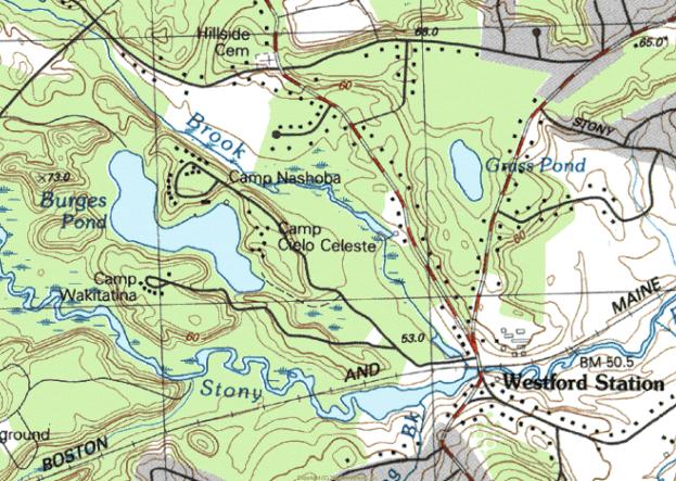
SKETCH MAP NORTH
TOWARD TOP
The landscape layout, appearance and gravestone art of the Wright Cemetery derive from design characteristics of the pre-industrial burial grounds. These characteristics consist mainly of the slate markers and the utilitarian, formerly agricultural landscape. The burial ground was owned until the 20th century by one of the many nearby farm families named Wright. In 1909, the town Cemetery Commissioners suggested the private cemetery be cared for by the town as were Fairview, Westlawn and Hillside Cemeteries. The parcel of land including the cemetery was later given to the town. Cemetery occupants influenced the town’s history and appearance and continue to do so by virtue of their artfully carved gravestones. War veterans, mill operatives, farmers and business people occupy the approximately 150 visible historic burials.
Markers are made mostly from slate as well as from other materials. The earliest gravestones are from the Federal Period and appear in the form of shouldered-arched and flat-topped stelae (rectangular or arched tablets or slabs), the largest of which belongs to Lieutenant Nahum Wight. (Note: There are occupants named both Wight and Wright.) Monuments from the Victorian Period take the form of an obelisk and carved marble stelae. Slate continued to be used until 1854 although marble and granite were becoming more common at that time. Grave markers are mostly arranged in rows oriented east to west with inscriptions on older stones typically facing south.
Land comprising the Wright Cemetery belonged in 1836 to Bela Wright who was granted, with some neighbors, permission by the town to keep a burial ground. The appearance at the time was likely that of a field of grass with a few small slate gravestones. The nearly square, flat, grass-covered parcel is located along the north side of a straight segment of Groton Road (State Route 40).
Boundaries of the cemetery are lined on the north, east and west with a fence four feet in height consisting of granite posts and 4”x4” rails. The Groton Road (south) boundary has a two- to four-foot high mortared fieldstone wall with split granite capstone. Entrance to the cemetery is thorough an opening in the wall at about the mid-point where a pair of stout, low granite posts support a wooden gate. Pedestrian access is through gaps beside the gate and secondary granite post. A modern flagpole occupies a site just inside the east entry. Historic burials occupy approximately ½ acre while the remaining four acres of reserve ground are in an undeveloped farm field outside the historic granite post and wood rail fence. Granite elements may have been quarried locally given the prominence of that industry in the north part of town.
Plot definition occurs in three instances with simple granite curbs. The most pronounced is approximately 24 inches in height and encompasses the Albion Wright family plot. Steps to access the plot are flanked by low pyramidal piers which also mark the corners of the plot. Other plot-defining curbs lack corner piers and rise only slightly above ground level. Curbs enclose square and rectangular plots of from eight to twenty feet per side.
The Wright Cemetery reflects trends in gravestone development in its variety of slate, marble and granite markers. Slate and marble are the oldest surviving materials used for marking burials. Slate is frequently carved in shouldered arches that range in height from one foot to approximately five feet. They can demonstrate a relatively crude, hand cut appearance, a well-designed and possibly machine cut sharpness and several levels of workmanship in between. Quality of workmanship of the slate marker is sometimes obscured by the fact that the stone has deteriorated or been broken. Inscriptions also vary in quality and detail. The simplest have fine, narrow letters with little relief or depth. Later slate stones from the 19th century are more likely to demonstrate clear, deep, stylized letters with a pronounced serif, well thought out organization relative to the shape of the stone, and a tooled finish to set off the inscription panel, ornament and banding at the edge of the stone.
Slate markers from the earliest period appear in a variety of shapes. Many are rectangular with an arched top, which may be representative of the figurative portal between life and death. The shape is also considered an abstraction of the human head and shoulders. This form of marking the passage from life is a Puritan concept brought from Boston and elsewhere during the region’s period of first settlement and endured in to the early 19th century. Eighteen slate markers exist in Wright Cemetery and have dates from 1819 to 1854. Miss Sally Stevens (d. 1848 at 43 years of age) has a typical shouldered arch-topped slate marker. It is inscribed with urn and willow motif above a central oval panel for inscription of her name and dates. Flanking the inscription are classical columns of the Doric order. This was the work of B. Day, gravestone carver from Lowell, Massachusetts.
Prior to the Federal Period, the event of death was considered a common reality whose dim portent reflected the stern view of life as a struggle for survival. Subsequently, New Englanders’ view of death adopted a sentimental quality that spoke more of the emotional state of those left behind than of the journey of the deceased, causing the replacement of darkly spiritual carvings with abstract sorrowful imagery. Urn and willow designs begin to appear on gravestones in the late 18th century and are based on classical influences exerted by the spreading glow of the Enlightenment. Both slate and marble markers exhibit this late 18th and early 19th century motif that is an icon of sorrow and grief. A highly ornamented slate marker is that of Lucy Osgood from 1854. The arched top is decorated with an urn and willow motif carved with a high level of detail including the oval background that has a hatched or tooled finish. The use of classically inspired columns in gravestone design, frequently of the Doric order, is evidence of the pervasive influence of classical imagery popularized by the Enlightenment. The stone of Nahum Wight has a design similar to Lucy Osgood’s and includes Doric columns beside the inscription panel as well as tooled finish and geometric rounds, symbols of the eternal nature of death.
Additional marker types in the form of an obelisk, Gothic designs and marble tablets with biblical and classical symbolism appeared during the Victorian Period. The single obelisk in Wright Cemetery is carved from gray granite and commemorates the lives of Joel Wright (1782-1834) and his wife Sally (d. 1869 at 79 years of age). This is the cemetery’s tallest marker at around 10 feet. Gothic themes are carved into some markers, including the pointed arched stone of Mary Wright who died in 1871 at the age of 21. Her marker has a recessed circle with inscribed flowers. Beside her grave is a small slant marker inscribed with the word “baby”, a common Victorian marker for those who died very young.
Marble markers from the mid 19th century are usually rectangular with a flat top but sometimes have a cambered (segmental arched) or pointed top. Asa (d. 1877 at 78 years of age) and Bathsheba Wright (d. 1869 at 68 years of age) have matching marble stelae with cambered tops. These three-foot high stones, which have edges set off by moldings, pendants and chamfers, are set on plinths and pedestals. Other marble tablets have tops articulated by a gradually sloping point that were erected in the mid 19th century. For example, Abbie M. Edes (d. 1859 at 15 years of age) and her relative Elvira (d. 1876) have this type of stone as does Nathan Wright who died in 1846 at 57 years of age.
20th century military stones exist in the Wright Cemetery. A small rectangular bronze marker mounted flush with the ground marks the resting place of Albert Picking (1915-1994) who served in the U. S. Army as a sergeant in World War II.
Gravestones in the Wright Cemetery bear some identifying inscriptions by their carvers. B. Day is by far the most frequent name, appearing in around six instances. Markers for Sally Stevens (1848), Abigail Wight (1850), Nathan Wright (1846), Walter Wright (1830) and Abigail Wright (1835) were carved by Mr. Day. He worked in Lowell and craved gravestones now in cemeteries in many surrounding communities. Carvers T. Warren and D. Nichols, both of Lowell, carved the marble pointed arched stelae of Caleb Wight and Hannah Ryan from 1864 and 1863. A. Sawtell of Groton carried out the shouldered arch form with urn and willow design on Lucy Osgood’s slate marker from 1856. The Lowell shop of Andrews and Wheeler has one stone to its credit in the Wright Cemetery.
Existing Conditions
Repairs have been carried out in the cemetery on a regular basis since the 19th century, altering only slightly the appearance from its Federal Period beginnings. Slate stones are particularly susceptible to cracking and toppling given the weak structural nature of the material. Several different methods have been used to stabilize markers. There are some which have been re-set in concrete footings poured at ground level. Others have been re-attached at severed points with metal braces and bolts or cemented or glued across fractures. Both these measures were taken in order to conserve the 1846 marble marker for Nathan Wright. Most stones remain in good to excellent condition. Some slate markers are difficult to read due to erosion. While very little vandalism appears to have taken place, damage has been sustained in many cases due to scraping by lawn-mowing equipment. Few ornamental plantings remain from past landscaping efforts.
Aside from routine maintenance, repairs and some deterioration over time, few changes have occurred in the Wright Cemetery. While records do not indicate as much, it is possible that, since few remain, footstones were removed as part of past efforts to tidy the grounds. However, the large number of remaining 19th century markers makes it possible to get a clear sense of historical burial and gravestone carving techniques in Westford.
The Wright Cemetery retains integrity of materials, design, workmanship, feeling and association. It is eligible for the National Register under Criteria A and C at the local level and meets Criterion Consideration D as a cemetery which derives its significance from distinctive design features and association with historic events. The cemetery is significant under Criterion A for its association with historical events in the community such as service in the Revolutionary War and establishment of family burial grounds during the early 19th century. It is eligible under Criterion C as an example of a burial ground containing gravestone carving representative of techniques commonly used in the period. The period of significance for the cemetery begins at its establishment in 1819 and extends to 1952. It has been in continuous use.
Westford’s Wright Cemetery first came into use around 1819, which is the time of the earliest death date on a gravestone. The town of Westford granted the privilege of a burying ground on Groton Road (then called the North Road) in 1836. Approximately two dozen stones survive from the first half of the 19th century. Gravestone ornament at the time was restrained and the surrounding landscape was allowed to appear as a grassy plot marked by slate headstones. The most basic of maintenance schedules has allowed the cemetery to retain much of its historic appearance by virtue of the densely grouped slate markers near the road, the small scale of markers and the simple landscape unencumbered by modern paths and furniture. Burials are ongoing in the Wright Cemetery.
The Wright Cemetery was the fourth of the town’s historic cemeteries to be established. Westford’s earliest cemetery was originally called the East Burying Ground and is now called Fairview Cemetery. This is on Main Street east of the town center and came into use around the turn of the 18th century. The second burial ground was the former North Burial Ground established in 1753, now called Hillside and located at the corner of Depot and Nutting Roads. The West Burial Ground or Westlawn was established in 1761 on Concord Road at Country Road. Nearly all of those interred here belonged to the First Parish Church until 1829, the time of the founding of the Congregational Church.
The Wright Cemetery occupies land that had been in use in the 18th century as farmland belonging to one branch of the large Wright Family. Among the founders of the cemetery was an area resident named Bela Wright to whom, in 1836, the town voted to grant “the privilege of a burying ground on the North Road, between Caleb Wight’s and Reuben Wright’s, which is to be free of expense to the town.”
Records from an early meeting of Wright Burying Ground proprietors held on June 3, 1837 and recorded in the Records of the Proprietors of the Wright Burying Ground indicate the full list of founding residents as follows: Caleb Wight, Horatio Wright, Bela Wright, Walter Wright, Martin Wright, Asa Wright, Benjamin L. Wright, Jesse L. Wright and Joel A. Wright. Votes were taken at the meeting to name Caleb Wight as moderator and Jesse Wright as clerk. Caleb Wight was determined to have care of the burying ground. A single lot was voted to be kept for burials of strangers. Caleb Wight was chosen as agent to sell lots.
There are eight gravestones with dates prior to the privilege granted by the town. These include Lieut. Nahum Wight (d. 1834 at 89 years of age), Abijah Wright (d. 1834 at 54 years of age), his wife Mary (d. 1831 at 55 years of age), Ellen Wright (d. 1830 at 28 years of age) and her children Francis and Henry who both died at less than one year of age in 1827 and 1828. Also, a single rectangular stele exists for two brothers, Jotham and Edmund Wright, whose deaths occurred in 1828 and 1819. However, this stone may be a cenotaph (a stone commemorating the death of a person interred elsewhere) since the Wright Brothers died in Dayton, (spelled Daton) Ohio and Mobile, Alabama. Jotham was a graduate of Harvard College in 1817. Other burials whose markers do not survive may also have occurred before the official establishment of the Wright Cemetery.
Gravestones from the first half of the 1800s are typically located very close together. Family members tend to be adjacent to one another, frequently aligned in the order in which they died. No segregation based on ethnicity, occupation, military service or wealth is apparent. Most stones are around the same size, two to four feet high by one to three feet wide. Maintenance of the burial ground during this period was presumably the responsibility of a Wright family member.
Nineteenth century residents of Westford who are buried in the Wright Cemetery consist mostly of farmers, several of whom were military veterans. Cemetery founder Bela Wright (d. 1859 at 62 years of age) worked as a farmer and lived 1/2 mile to the south on the current North Main Street. He also served in the War of 1812 according to notes to that effect printed in the 1896 Town Report. His relative Asa Wright (d. 1877 at 78 years of age) was also a farmer but lived in the village of Westford Center. His death was brought about by a suicide drowning according to the historian Marilyn Day in her 1998 book Westford Days. Parker Wright (b. 1791) was another occupant of the burial ground to have served in the War of 1812.
Lieut. Nahum Wight was born in Medfield, Massachusetts and served in the Revolutionary War. Lieut. Wight (also spelled White in Massachusetts Soldiers and Sailors of the Revolutionary War) served as a corporal under Captain Benjamin Bullard from Sherborn and marched on Concord in April 1775. He also served in the Continental Army at Fort Ticonderoga, among other campaigns. After living most of his life in Medfield and Sherborn, he moved to Westford, possibly to be near his son Caleb and his family. Nahum is buried next to his wife Abigail (d. 1850 at 90 years of age). Caleb Wight (d. 1864 at 77 years of age) lived in Westford Center, worked as a farmer and served as a deacon, probably in the Union Congregational Church, of which both he and his parents were founding members in 1828. Caleb Wight also served in the War of 1812. Mr. Wight is buried next to his wife Mary (d. 1869 at 80 years of age) and daughters Joanna (d. 1837 at age 24) who died at Plymouth, Michigan, Harriet (d. 1854 at age 37), Lucy Osgood (1821-1856) and Caroline (1819-1882).
The largest grave marker in the Wright Cemetery is that of Joel Wright (1782-1834) and his wife Sally (d. 1869 at 79 years of age). The grey granite obelisk is approximately 10’ high. Mr. Wright served in the War of 1812 at Boston’s Fort Warren under Lieut. Col. Jonathan Page. Approximately 100 markers from the period exist in the cemetery.
During the mid 19th century, the Burial ground had a white picket fence at its edge. The Records of the Proprietors of the Wright Burying Ground, kept from the time of the founding of the burial ground has a small number of sporadic entries thereafter. One entry indicates Ansil Davis was paid $7 for whitewashing the fence in 1847.
During the 19th century, the Wright Cemetery was privately owned and maintained. This is in distinction to the East (now Fairview) West (now Westlawn) and North (now Hillside) Cemeteries, which since at least 1840 had received care by a neighbor at the expense of the town. In 1909, the Cemetery Commissioners noted in the town report that “Parties interested in the private cemetery called the Wright Cemetery at the north part of the town have expressed a wish that the town assume the care. Your commissioners recommend it be done”. No caretaker is specified in town reports for the Wright Cemetery, as was done for other cemeteries, until the middle of the 20th century. However, military veterans in the cemetery did receive commemorative markers at the expense of the town starting around 1909. Since scant mention is made in public records, it is difficult to determine the date of construction for the ashlar granite wall that separates the cemetery from the road or names of those who may have built it. This is also true of the granite post and wood rail fence surrounding the cemetery.
World War II veterans are buried in the Wright Cemetery, at least one of which has a military marker. Albert H. Picking (1915-1994) served in World War II and is buried under an arched granite slab. His military service is as a sergeant in the Army is remembered by an adjacent bronze tablet mounted flush with the ground. He is buried with his wife Bernice Picking (1915-1996). Mrs. Picking lived her entire life at the farm ¼ mile to the west of the Wright Cemetery.
Interments continued throughout the period with granite being the gravestone material of choice. The 1937 town report includes a sample contract for purchase of burial plots that indicates no walls, fences, curbs or projecting corner posts were allowed, probably to simplify maintenance. This regulation, instituted by the Cemetery Commission, served to stem the installation of new ornament in cemeteries and to encourage removal of furnishings that may have been installed in the Victorian Period, although no such activity is documented. Sebastian Watson, Fred Blodget and Axel Lundberg served the town as cemetery commissioners from at least 1937 though 1949. Town employees performed work at the cemetery in 1960 that included painting and repairing the fence, cutting brush and planting new shrubs. Few ornamental plantings remain.
Colonial, Federal and Victorian period historical associations of the Wright Cemetery are largely intact despite interruptions by the small number of modern markers and the smaller amount of documentation compared to the town’s other cemeteries. The possibility remains, by observing the rows of arch-topped slate stones carved with urn and willow designs, classical columns, and by recalling names so important to the development of the community, to get a strong sense of how 19th century residents of the Town of Westford experienced their burial places.
A diseased elm tree was cut down in 1963. The existing gate was installed with original hinges and nails in 1975 during the Bicentennial period when all of Westford’s cemeteries were recognized as important resources for the historical appearance they retained and for the accomplishments of the Westford residents interred there. The stone in the wall with the inscribed name was given to the town by Carl Wright in 1977.
Wright Cemetery comprises all of the land within the boundaries of the cemetery. It is bounded by Groton Road on the south. The cemetery encompasses 4.5 acres, described by the assessor’s office as parcel 5 on map 35.
Boundaries of the cemetery were determined by the Westford Historical Commission and by the consultant. Boundaries include all gravestones, burial-related buildings, structures, circulation paths and ornamental plantings. Stone walls encircle the cemetery and mark all boundaries.
SKETCH MAP NORTH
TOWARD TOP
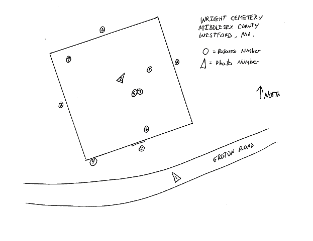
SKETCH MAP NORTH TOWARD TOP
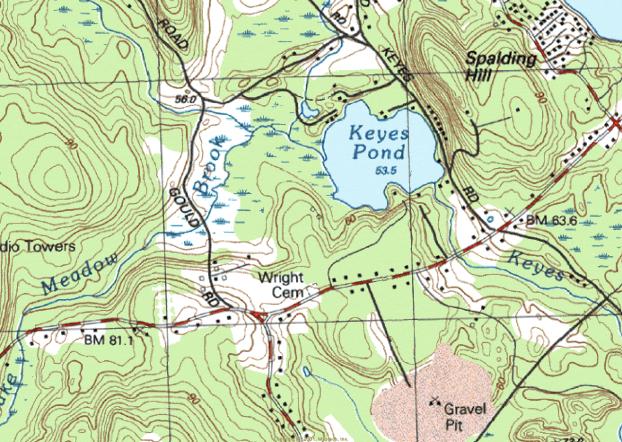
SKETCH MAP NORTH TOWARD TOP
The landscape layout, appearance and gravestone art of Westford’s Russian Cemetery derive from design characteristics of the Early Modern Period with a Russian Orthodox religious influence. These characteristics consist of the flat, utilitarian landscape and, more importantly, the markers that are made primarily of granite, approximately 15 of which have free-standing crosses on top carved from stone. Many others are inscribed with distinctive Russian orthodox crosses. Land of the cemetery was privately owned until 1918 when the need was felt for a burial place for immigrant factory laborers who were mainly of Russian origin. A small number of interments are of immigrant laborers of Polish and other origins. Many of the approximately 300 Westford residents interred here were recruited as teenagers and young adults at their Russian and European villages for work in Westford’s mill villages by traveling company operatives. Approximately 50 stones bear death dates between 1918 and 1960. The immigrants influenced the town’s history and appearance and continue to do so by virtue of their artfully carved gravestones. The burial ground is located on the north side of Patten Road.
Markers are made almost exclusively from grey, pink and black granite with one cast concrete example. The earliest markers are from the Early Modern Period and appear in the form of nearly square tablets on a square plinth, occasionally with crosses mounted on top. Many inscriptions, including those on the earliest and largest markers, are in the Cyrillic language. Other markers have English language inscriptions with simpler stone designs in the form of rectangular tablets which lack the free-standing cross. Grave markers are arranged in rows oriented approximately north to south with inscriptions typically facing west.
Land comprising the Russian Cemetery belonged in the 19th century to the Blood family and later to the Read family. The flat, nearly square parcel was likely in use as farm land at that time. Entrance to the cemetery is through two gateways in the stone wall along the Patten Road (south) side. Gateways along the southerly edge are flanked by a pair of stout, low ashlar piers with cast stone pyramidal caps. The three-foot high stone wall is split granite ashlar with a capstone. Plot-defining features inside the cemetery, such as granite curbs or plot corner stones, do not exist. Circulation among graves is via a U-shaped asphalt driveway that enters and exits from Patten Road.
The Russian Cemetery is characterized mainly by its granite tablets, the most ornamental of which are topped by a free-standing Latin cross cut from granite. Ranging in height from three feet to approximately six feet, this type of marker is articulated in approximately 15 cases with a Cyrillic language inscription. Those written in English are simple in language and basic in detail. Typical inscriptions have names and dates rendered in a simple style of script. The earliest marker has a square plinth with nearly square black granite tablet on top which bears the Cyrillic inscription and the death date of 1918. Ornament consists of the free-standing Latin cross inscribed with the letters IHS. Other markers have the square tablet on the plinth with no free-standing cross. More recent markers are simple rectangular tablets with low arched tops.
Examples of grave markers with the free standing cross include that of George (1887-1946) and Annie (1896-1991) Butko. The cross on this grey granite example is inscribed with letters IHS which stand for "Jesus" or “In His Service” or "He Is Risen". Matrona (1890-1933) and Andrew (1882-1956) Prowker and their child Antonia (1912-1927) have a grey granite tablet with free standing cross inscribed in the same way. Many other such markers have Cyrillic inscriptions. Some black granite examples exist. Most others are grey and blond in color.
Markers exist which lack the free standing Latin Cross but bear the Russian Orthodox Cross as part of the inscription. The Russian Orthodox Cross is unusual because it has three bars instead of the more common single bar as seen in the Latin Cross. The top bar is narrower than the others and bears the title board in detailed versions. The middle bar is the widest of the three and is the one on which the Lord’s hands are nailed. The bottom bar is not only narrower than the middle but is oriented at an angle to the central stem. This is the bar on which the Lord’s feet are at rest. Markers in the Westford Russian Cemetery with the Russian Orthodox Cross inscribed in the low arched top of the tablet include the pink granite marker of Matthew Sudak (1896-1951), the grey granite stone of Luke (1893-1974) and Mary (1891-1945) Archinski, the wider pink granite arch topped marker of Peter (1886-1956) and Alexandra (1896-1953) Talanetz as well as many other similar examples. The Latin Cross also appears as the main ornamental component in the inscription on some stones.
20th century military markers exist in the Russian Cemetery. A small rectangular bronze marker mounted flush with the ground marks the resting place of Alexander Belida (d. 2001) who served in the U. S. Army Air Forces as a sergeant in World War II. A granite example of the flush military marker is that of Nicholas Sudak Jr. (1917-1984) who served in World War II as a staff sergeant. The stone is ornamented with a cross inscribed in a circle. Approximately a half-dozen similar examples exist.
Gravestone manufacturers identified their work in some cases by attaching metal tags to markers. Pre-1960 stones with identifying tags include the 1933 example of Matrona and Antoni Prowker which bears a bronze tag stamped “Lowell Monument Co., manufacturers, Lowell, Mass”. Mary and Steve Belida’s 1951 stone has a tag stamped “Luz Brothers, 1022 Gorham St., Lowell, Mass.” This stone is also etched with the “Barre Guild” seal, signifying the monument as a product of the Barre Granite Association of Barre, Vermont. Locally made markers include that of Demitry and Vera Belida’s 1960 stone made by the Barretto Monument Company of Groton Road in Westford. Peter and Mary Worobey’s 1941 marker was sold by A. G. Lundberg of Westford. This is Axel G. Lundberg, Cemetery Commissioner in the 1930s and 1940s who had a granite shop on Brookside Road. Other stones were purchased from University Monumental Works on Berkshire Street in Cambridge. Stones from this period appear to be pre-manufactured stones with stock designs created prior to purchase.
Most stones remain in good to excellent condition. Very little vandalism appears to have taken place. The single cast concrete grave marker has no inscription and it is impossible to discern whether or not it had one that is now lost. Boundaries of the cemetery are marked by modern chain link fence on the east and west sides with a wire fence supported by stakes on the north or rear edge. A modern flagpole rises from the northern section.
Few changes have occurred in the Russian Cemetery since its inception in 1918. The large number of remaining markers with Cyrillic language inscriptions and the proximate birth dates of the occupants who arrived during a short span of time in the early 20th century make it possible to get a clear sense of local trends in immigration and factory employees’ ethnicity in Westford. This is the only historic cemetery in the town dedicated to a group with particular national affiliation. A Catholic cemetery exists on Pine Ridge Road.
The Russian Cemetery retains integrity of materials, design, workmanship, feeling and association. It is eligible for the National Register under Criteria A and C at the local level and meets Criterion Consideration D as a cemetery which derives its significance from distinctive design features and association with historic events. The cemetery is significant under Criterion A for its association with events in the community such as immigration by factory workers. It is eligible under Criterion C as an example of a burial ground containing gravestone designs that are unusual in the community. The period of significance for the cemetery begins at its establishment in 1918 and extends to 1952. It has been in continuous use.
Westford’s Russian Cemetery first came into use in 1918, primarily to accommodate burials of immigrant mill workers from that country. Significant numbers of Russian immigrants began to arrive in Westford during the first decade of the 20th century as the result of recruiting efforts by mill company agents in Belarus as well as other regions of Europe. The cemetery remains in use today, largely by descendants of mill recruits. Some Polish immigrants accompanied the Russians to Westford’s mill villages and are interred here as well. The history of Westford’s mill villages includes periodic trends in immigration of several ethnic and national groups starting with the Irish in the 1840s. French Canadians also arrived in large numbers as did residents of Sweden, Italy, Scotland, England and other nations. While Catholics of many nationalities did choose to create a cemetery of their own in the town, no other ethnic or national group in Westford has as important and distinct a resource as the Russian Cemetery to symbolize their history in the town. The cemetery provides information concerning not only names and dates of individuals interred therein but contextual documentation of the typical immigrant in terms of age and marital status. The cemetery itself stands as a testament to the solidarity of Westford’s Russian immigrant population.
Ethnicity and national origins of residents of the town underwent change during the mid-late 19th century from a mainly native-born group to one of significant foreign-born population. Residents were almost entirely of English descent until 1850 when census records show the first Canadian and Irish immigrants. In the 1865 state census, approximately 20% of the residents were foreign-born. By the end of the century the percentage of foreign-born residents was more than half according to Annual Town Reports. Federal census figures from 1910 confirm the dramatic increase in the number of foreign-born Westford residents around the turn of the century. Groups of nationalities with representatives numbering in the hundreds include Canadians, Russians, Italians and Irish. Smaller groups were Swedish, Scottish, Austrians and English. In 1907, Russians begin to appear on lists of Westford residents and in marriage records.
In 1912, agents of the Abbot Worsted Company traveled to the Russian region of Belarus and the city of Grodno in order to recruit additional laborers with the promise of steady work, good housing and prepaid travel expenses. The agents’ success and a sudden increase in Russian residents is reflected in census information and is confirmed in reminiscences of former Abbot Worsted employees. Census information reveals that Russians were most likely to be listed as woolen mill employees as opposed to Italians in Westford who were most commonly described simply as laborers. Every resident in the resident directory for 1920-21 with a Russian surname was employed by either the Abbot or the Sargent mills in Forge Village or Graniteville although it is suggested by current residents that some members of the group also worked in stone quarries in the north part of town. The Abbot Worsted Company manufactured woolen yarns in Forge Village and Graniteville with machinery made in Graniteville by the C. G. Sargent & Sons machinery manufacturing company. Based on gravestone inscriptions, it is apparent that the immigrants were between 16 and 31 years of age at the time of embarkation to America.
Grodno is located in northwest Belarus, bordered on the north by Lithuania and on the west by Poland. The population was largely Byelorussian, Lithuanian, and Polish, some of whom immigrated along with their Russian neighbors. Industrial products in Grodno were diverse and included textiles. According to a Grodno municipal website, there were in 1897 over 100 residents involved in manufacture of textile fabrics which may have been influential in the Westford mill company agents’ selection of the region for labor recruits. Since working conditions in the Russian factories were distasteful and included long hours and poor pay, Abbot Company employees achieved success in their efforts to swell the ranks of mill hands in Westford’s modern, well-managed facilities. The Abbot Worsted Company also mounted successful efforts to entice Canadian emigrants from Trois Rivieres in Quebec and English workers from the city of Keighley in Yorkshire.
Russian Cemetery occupants appear to have been married either before they arrived in America or to have married fellow immigrants judging by the ethnic tone of the given names of many couples in the Russian Cemetery. It is noteworthy that nearly all were married one time. Residents whose spouses died earlier than themselves tended not to remarry as did members of other groups.
One of the many benefits for immigrants was the availability of English language classes, which were held in the Abbot Worsted Company-built social halls, two of which were located in Graniteville on Cross Street and on North Main Street. Other company social halls were in Forge Village on Bradford Street and in the Brookside Village (MHC ) on Brookside Road. Immigrants occupied the rented single and multiple dwelling-unit houses in mill neighborhoods in increasing numbers until the mid 20th century when the wool industry in New England had entered decline. During that time, residential subdivisions had been built on Abbot, Palermo, Orchard, Pine, Lincoln, Elm, Smith and Pershing Streets in Forge Village and River, First, Second, Third and Fourth Streets in Graniteville, among others. All these residential streets were home to Russian mill employees.
Russian immigrants who occupy the cemetery and whose names can be matched to residents on voting lists and resident directories from the 1920s and 1930s include Forge Village residents Peter Britko (1894-1977) and his wife Alexandria (1894-1957) at 7 Canal Street from 1924-1928; Peter Talanetz (1886-1956) and his wife Alexandra (1896-1953) at 8 Canal Street in 1924 and 6 Palermo Street in 1928; Peter Worobey (1891-1991) and his wife Mary (1893-1941) at 2 Canal Street in 1920-1928; Michael (also Mika) Salaliko (1881-1956) and his wife Marcella (1885-1934) at 6 Canal Street in 1924; Stephen Harachko (also Harachka, 1884-1976) and his wife Dominika (1890-1969) at 21 Chestnut Street in 1924 and 25 Chestnut Street in 1928; Jacob Tereshko (1896-1987) and his wife Axzenia (1893-1965) at 15 Oak Street in 1924 and 1928. Wasil Beskalo (1890-1969) and his wife Fedora (1895-1980) lived in Graniteville at 17 First Street from 1921 to 1928.
The Russian Cemetery evokes the heritage and cemetery design practices of a major group of immigrants to the town. The Russian immigrants’ group history can be related by observing the gravestones with their proximate birth dates and names that are so unusual compared to those of English descent in other cemeteries in the town. The unusual appearance of the gravestones with the free-standing crosses on top combined with the Cyrillic letters, altogether unusual in Westford, further distinguish the cemetery from others in the town. These differences are a reflection of part of the broad spectrum of the community's history and culture. Survival of the cemetery is the most significant reminder of this important element of local culture.
The Russian Cemetery comprises all of the land within the boundaries of the cemetery. It is bounded by Patten Road on the south. The cemetery encompasses 1.33 acres, described by the assessor’s office as parcel 27 on map 54.
Boundaries of the cemetery were determined by the Westford Historical Commission and by the consultant. Boundaries include all gravestones, burial-related buildings, structures, circulation paths and ornamental plantings. Stone walls encircle the cemetery and mark all boundaries.

SKETCH MAP NORTH
TOWARD TOP
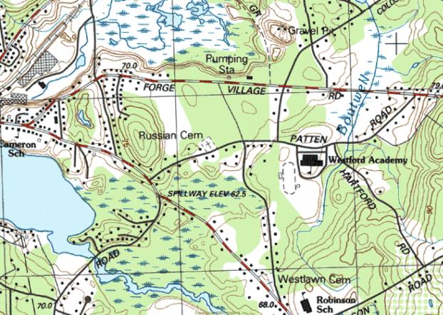
SKETCH
MAP NORTH
TOWARD TOP
The John Proctor House, Westford, Massachusetts, is a well-preserved, late First Period house of timber-frame construction (ca. 1720-1740) that has been enlarged by a two-story addition at the west elevation (ca. 1840-1870) and a one-story rear wing (ca. 1870-1910). Originally built as a center-chimney dwelling, the John Proctor House was modified in the early eighteenth century by the removal of the original western bay and now stands as a half-house.
Surrounded by fields and woods, the John Proctor House stands on its original site facing south across Concord Road, a main transportation route established prior to or during the early seventeenth century. Immediately adjacent to the house are a modern garage and a cellar hole, elements of which may date from a nineteenth century barn (although concrete facing suggests twentieth-century rebuilding). The surrounding vicinity is rural and consists of scattered former farmsteads, over 100 acres of conservation land, and some recently built homes which are not visible from the nominated property.
The John Proctor House rests upon a low fieldstone foundation. The exterior elevations are covered with wooden clapboards and are trimmed with simple flat-board friezes and corner boards. Similarly, the front entry and the window surrounds feature flat-board casing. Due to the removal of the original western bay in the early nineteenth century, the main entry is positioned asymmetrically towards the west and stands above the façade’s gabled roof, and its slight eave is decorated with a boxed cornice and cornice returns. A narrow brick chimney stands at the west elevation (north of the windows), and a second chimney pierces the front-gabled roof of the north elevation addition.
The sparse fenestration of the John Proctor House façade is typical of the First Period design. It consists of one 6/6 double-hung sash window east of the entry at the first story, one 6/6 double-hung sash window at the east bay of the second story, and one smaller 4/4 double-hung sash window positioned over the entry. The top rails of both second story façade windows intersect the frieze, which may be due to the presence of earlier casement window openings, which were enlarged during the nineteenth-century installation of larger double-hung sash windows.
The John Proctor House consists of two bays, one is framed into a former chimney bay (west, approximately 9’ wide) and the other is a room bay (east, approximately 18’6” square). Framing members consist of flared oak posts, large girts, and boxed plates. The floors of the main house are supported by a transverse summer beam (13” x 12’6”) at the first story and a square longitudinal boxed summer beam (15’6”) at the second story.
The attic is framed into three bays by principal rafters that rise to a small ridge-pole which has been replaced at the western bay (original chimney location); purlins are irregularly spaced and bear evidence of alteration with salvage materials. About 1900, a one-half story balloon-frame rear ell was added; interestingly, the ell is butted against the north elevation without altering or being tied into the house’s original frame.
Most of the present interior woodwork and plaster of the John Proctor House appear to date from the second quarter of the nineteenth century. The wall thickness at the façade (10”) and rear wall (11 ½”) suggest that current finishes have been applied over earlier finishes. The 6” thickness of the west side wall reflects its alteration in the nineteenth century; the east side wall is only 6” thick at the first story, as a result of the replacement of its sill and studs in the first half of the twentieth century.
Richard and Alan Emmet, who have owned the house since 1970, have undertaken some basic repairs and maintenance; the John Proctor House and surrounding acreage, however, survive remarkably intact. The nominated property includes 1.16 acres of land surrounding the John Proctor House, with 247.68 feet of frontage on Concord Road and a northern lot line of 217.92 feet. The Emmets have donated the remaining acreage of the John Proctor House premises to the Massachusetts Audubon Society as part of a larger tract which is a designed wildlife sanctuary.
The main house (ca. 1720-1740) was built by John Proctor II (1694-1783) of Westford, Massachusetts. Although originally constructed as a center-chimney, timber-frame house, early deeds from John Proctor II to his sons, Phineas Proctor and John Proctor III, refer to divided use and ownership among family members of the eastern and western sections.
In 1791 a Proctor descendant, James, sold a large tract of the Proctor Farm and the eastern half of the John Proctor House to a non-family member, while Sarah Wright Proctor (the widow of John Proctor II) continued to live in the western section of the house until her death in 1827. The John Proctor House was physically reduced to a half-house in 1827 when the western section was sold to Henry Fletcher, a neighbor. Two flared posts used as plates in an 1827 addition to Henry Fletcher’s barn offer evidence that framing elements of the Proctor House may have been re-used in this location.
Deed references indicate that Henry Fletcher probably dismantled a large center chimney along with the western bay of the John Proctor House in 1827, requiring the owner of the remaining eastern section to undertake major changes in order to live in the divided structure. At this time, a smaller chimney (now capped below the roof line) was constructed at the west elevation and set 4’ into the former hall and hall chamber area in a position slightly east of the original chimney.
A small room was created in the former center-chimney bay, and it is likely that the west elevation addition was constructed ca. 1840-1870 to create usable rooms at the first and second stories of the house’s west end. Other changes made at that time probably include the enlargement of existing window openings to their present dimensions and the cutting of new windows on the house’s east end. The present exterior boxed cornice was likely added between 1830 and 1850.
In 1874 Lizzie Martin of Boston purchased the John Proctor House and 12 acres of land for $1,100. In 1881 Mrs. Martin and her husband Frederick purchased a 30-acre parcel abutting the house to the east and north. (This property adjoined the west boundary of the Henry Fletcher homestead.) In 1885 Mrs. Martin was taxed on a house, shed, barn, and 42 acres; by 1895 a henhouse existed on the premises as did 1 horse, 4 cows and 20 fowl.
As noted, the John Proctor House’s balloon-frame rear addition was built ca. 1900, and it appears that John Martin, son of Lizzie and Frederick Martin, and his family lived on the premises around this time because his wife Clara was listed as the owner of record on a 1915 tax assessment. It is believed that the Proctor Barn collapsed or was torn down prior to 1951, and a low metal-roofed shed (now removed) was built over the barn’s fieldstone foundations.
After Mrs. Clara Martin died in 1959, her two unmarried sons, John and Clarence Martin, lived on the premises until 1970 when they sold the John Proctor House and 42 acres to Richard and Alan Emmet. The Emmets, who have lived in the neighboring Henry Fletcher House since 1951, continue to own the John Proctor House and rent it to residential tenants.
The John Proctor House, initially constructed between 1720 and 1740, is important for its surviving elements of First Period architecture in addition to the well-preserved, mid-nineteenth-century interior finishes and exterior elements, resulting from modifications made between 1827 and ca. 1850. The house also possesses historical associations with the family of Robert Proctor, one of the first settles of Westford. The John Proctor House retains a high degree of integrity of setting, location, feeling, design, materials, and association which are further enhanced by an architecturally significant dwelling retaining original materials and workmanship exemplifying traditional construction during Westford’s earliest period of settlement and reflecting nineteenth-century building practices in Westford. The John Proctor House thus fulfills National Register Criteria A and C on the local level.
Originally the hunting ground of the Pawtucket, Wamesit, and Nashoba Indians and formerly the “West Precinct” of the Town of Chelmsford, Massachusetts, the Town of Westford is located 24 miles northwest of Boston and 7 miles southwest of Lowell in the northern section of Middlesex County. Westford’s boundaries encompass 31 square miles, comprised mainly of rolling upland terrain with numerous brooks, ponds and bogs. English colonial settlement began in the mid-seventeenth century. The first settles came mainly from the nearby towns of Concord, Woburn, and Wenham to obtain land, clear trees, build homes, and begin farming. The Nashua Valley corridor supported an agricultural economy and the water power of Stony Brook gave rise to local mill sites. Settlement was interrupted in 1675 by King Philip’s War. Re-settlement proceeded slowly, and Westford remained part of Chelmsford, Massachusetts, until 1729 when acting Governor William Dummer signed an Act of Incorporation for the Town of Westford. Shortly thereafter, the boundaries of Westford were enlarged by the annexation of the Prescott, Kent, and Townsend family estates, which were previously part of the Town of Groton.
Between 1720 and 1800 Westford continued to exist as a farming community of scattered farmsteads situated on pre-established transportation routes. During this time, a town center also began to grow around the town common, the first Meeting house, and the town cemetery. In the early nineteenth century, the water power of Stony Brook lead to development of several small-scale industrial centers (Nabnasset, Graniteville, and Forge Village), and granite quarrying began in the northeast section of Westford in 1820. In 1855 the Abbot Worsted Mills, located first in Graniteville and later in the Forge Village area of Westford, began the manufacture of worsted yarns and attracted immigrants to Westford from England, Scotland, Canada, Ireland, Russia, Poland, and Italy.
With increasing competition from large upstate New York and Mid-west farms, New England’s overall agricultural productivity began to decline in the early nineteenth century. Westford’s long-established agricultural economy improved, however, during the Civil War era, and agriculture remained one of the primary occupations of Westford residents until after World War II. Dairy farming was predominant; although fruits such as apples, peaches, and strawberries were also sold profitably at Boston markets.
Due to the eventual decline of Westford’s agricultural economy in the 1950s and 1960s, many local farmers sold land to developers who were building new homes to accommodate Boston’s suburban expansion. Although Westford’s town center, mill villages, and some agricultural landscapes presently remain intact, increased access to the Boston highway system (via the extension of Interstate 495) and industrial expansion of surrounding communities have brought extensive suburban development to Westford during the past 20 years with consequent loss of former farmsteads and agricultural lands.
The nominated property, a two-story, timber-frame house, was built ca. 1720-1740 by John Proctor II (1694-1783), husbandman. John Proctor II was the grandson of Robert Proctor, a petitioner to the General Court in 1653 for the settlement of Chelmsford Plantation. When Robert Proctor moved from Concord, Massachusetts, to the “West End” of Chelmsford with his wife Jane Hildreth Proctor; and their four children between 1650-1656, the Proctors became one of the first families to settle the area and to begin farming. Robert and Jane Proctor had seven additional children’s births indicating that they remained in Chelmsford at least until the early 1680s.
In 1692 and 1693, Robert Proctor conveyed much of his property to his son John Proctor I, including among other parcels his “home Lott with a Dwelling house, Barn and other out houses Lands, Meadows & orchards” and a “parcel of Land called ye New Lott… bounded Southerly by the Highway…” Robert Proctor’s movable property was also included in the transfer “Excepting Such Cattle and household goods… reserved in another Instrument” and the right to cut wood on the east side of “the Ry Lott.” As all other parcels are described as meadows and woodlots, it is possible that the “New Lott” was already the home of John Proctor I and his wife, Miriam Proctor, at the time of transfer.
That the “New Lott” of Robert Proctor may have been the property at 218 Concord Road is possible but conjectural due to the imprecision of property descriptions and the lack of subsequent deeds until 1760 when John Proctor II sold several parcels to his son, Phineas Proctor. Included in the 1760 sale was a parcel of land that corresponds to 218 Concord Road together with one-half of the “Dwelling House & Barn” standing thereon. As John Proctor II was married prior to 1719 and was living in Westford at the time of its incorporation in 1729, it is probable, but not documented, that the present main house was standing by the 1720s.
Subsequently, in 1761 John Proctor II sold additional parcels to his son John Proctor III, yeoman (1733-1785). This sale included one-half of the house and barn of John Proctor II but apparently not the land on which they stood, as it had already been sold to Phineas Proctor. From 1761 to 1827 the western half of the house was occupied by the family of John Proctor III and the surrounding acreage was farmed. In the initial settlement of Proctor’s estate, the western half of the house and nearby land were granted to his widow, Sarah Wright Proctor; an inventory of the estate includes two sets of fire shovels and tongs with sufficient furniture to indicate that Proctor occupied at least two rooms and perhaps more. The inventory also lists the farm implements, livestock, and cooper’s tools that belonged to John Proctor III.
In 1782 the eastern half of the house and the land on which it stands were sold by Phineas Proctor, husbandman, to his son, James Proctor, yeoman. This conveyance also included 76 acres of land used for “orcharding mowing, plowing and woodland.” In 1798 James Proctor sold the eastern half of the house and an 80 acre farm to Abel White of Westford for $850, subject to a $400 Bank Mortgage. Between 1802-1819,ownership of the eastern half of the house with 12-acre tract of land changed hands several times before being acquired by in 1819 by Samuel Farwell, a cooper from Littleton.
Sarah Wright Proctor, the widow of John Proctor III, continued to live in the western section of the house until her death in 1827. Following the death of Sarah Proctor, the land that Phineas Proctor had purchased from his father was sold in 1827 to Henry Fletcher, the owner of neighboring property. Henry Fletcher also purchased the “West part of the House as far as the Senter of the chimney with the Sellar under the same—with ten feet wide in the southwest corner of the Barn Beginning at the floorway through to the West End with a privilege in the Thrashing floor.”
Insofar as the description of Fletcher’s purchase indicates that the John Proctor House was a full, center-chimney structure, rather than the present half-house, it suggests that Fletcher dismantled the chimney and western bay of the John Proctor House, requiring the owner of the eastern half to make major changes to the remaining structure. The use of two flared posts as plates in a 1827 addition to Henry Fletcher’s barn offer evidence that framing elements of the Proctor House may have been re-used in this location.
As noted, beginning in 1819 Samuel Farwell owned the eastern section of the John Proctor House and its 12 acre parcel. Farwell had married Mary Parker in 1813 (Mary Parker Farwell was a member of the established Westford family for which “Parkerville,” now “Parker Village,” was named) and, as discussed above, it appears that the Farwells modified both the exterior and interior of the house during the second quarter of the nineteenth century (1830-1850) in order to render the half-house more comfortable and attractive.
Even though Samuel was a cooper by trade, the Farwell family continued the tradition of farming; Mary Parker Farwell purchased an additional, non-abutting 30 acre parcel to the west of their home for this purpose in 1850. Samuel Farwell died in 1859, survived by his wife Mary and five grown children. The inventory of Farwell’s estate listed a house, barn, and land with personal property that included household furniture, dairy tools, two lots of casks, farming tools, three cows, one wheelbarrow, one lot of hay, and $100 in cash.
Beginning in 1866, the John Proctor House and 12 surrounding acres were sold three times before being purchased in 1874 by Lizzie Martin of Boston, Massachusetts. During this time, the John Proctor House continued to be a family farmstead, and Mr. and Mrs. Martin expanded their holdings in 1881 by purchasing a 30 acre parcel which abutted their house to the east and north and adjoined the west boundary of the neighboring Henry Fletcher House premises. Additionally, chicken and egg production became commercially important in Westford during the end of the nineteenth century, and by 1895 the Martins had constructed a henhouse to for their 20 fowl.
In 1915 Mrs. Clara Martin, the daughter-in-law of Lizzie and Frederick Martin, was the property’s owner of record on the local tax rolls. Successful farming continued into the early twentieth century, and the Martin family held 42 acres of land, the John Proctor House and Barn, a henhouse, a horse and cow, plus 30 fowl. The advent of the 1930s brought economic depression and a decline in farming in Westford. Active farming probably ceased on the property by the late 1940s, and it is believed that the Proctor Barn collapsed or was torn down prior to 1951. Clara Martin died in 1959, and her two unmarried sons, John and Clarence Martin, used the premises for residential purposes. In 1970 the Martins sold the John Proctor House and 42 acres to its current owners, Richard and Alan Emmet, who rent the house to residential tenants.
The Emmets donated a perpetual preservation restriction to the Society for the Preservation of New England Antiquities in 1990 in order to ensure that the historical and architectural integrity of the John Proctor House will continue to be preserved for generations to come. The restriction protects both interior and exterior features of the house, such as the foundation, all elevations, roof profiles, structural members, interior space configuration, floors, plaster walls and ceilings, woodwork and fireplaces.
The John Proctor House is significant as a rare survivor from the early colonial period of Westford, Massachusetts, and for its associations with Robert Proctor, who was one of Westford’s first settlers. Due to its well-preserved condition, the house contributes to the understanding of late First Period design and construction practices in Middlesex County and stands as an uncommon example of an eighteenth-century, center-chimney dwelling that was reduced to a half-house more than 100 years later. Built on an early transportation route, the John Proctor House and its intact setting also exemplify the agrarian life-style of many Westford residents between the eighteenth and early twentieth centuries.
The nominated property consists of Parcel A (1.16 acres) with the John Proctor House thereon, as more particularly described in a survey conducted June 10, 1991, by McGlinchey Associates, Inc. (attached as a site plan):
Parcel A Southerly by Concord Road two hundred forty-seven and 68/100 (247.68) feet;
Westerly by land now or formerly of Richard S. Emmet, Jr. two hundred ninety-eight and 93/100 (298.93) feet;
Northerly by land now or formerly of Richard S. Emmet, Jr. by several lines measuring together three hundred sixty-eight and 66/100 (368.66) feet; and
Easterly by land now or formerly of Richard S. Emmet, Jr. one hundred forty-eight and 45/100 (148.45) feet.
The boundaries of the nominated property include the immediate environs of the John Proctor House contributing to the historic integrity of the premises. The boundaries also reflect the creation of a 1.16-acre parcel surrounding the John Proctor House by its current owners, who have established preservation restrictions on this lot and have donated the remaining acreage to the Massachusetts Audubon Society.
The Henry Fletcher House, Westford, Massachusetts, is a two-story, five-bay, timber-frame dwelling of late-Georgian design with a rear ell and several twentieth-century additions. To the east of the house stands the Fletcher Barn, a two-story, timber-frame structure of two bays’ length; it possesses a main core contemporary with the Fletcher House’s initial period of construction (ca. 1810-1813).
Both the Henry Fletcher House and Barn stand on their original sites facing south across Concord Road, a main transportation route established prior to or during the early seventeenth century. The grounds, which include approximately 10.6 acres of land lying to the north and south of Concord Road, feature open fields, second growth woodlands, and low stone walls. The surrounding vicinity is rural and is comprised of scattered former farmsteads, over 100 acres of conservation land, and some recently built homes which are not visible from the nominated property.
The Henry Fletcher House was built in several stages and consists of a two-story main house (ca. 1810-1813); an extensively modified one-story rear ell (ca. 1810-1820, sections ca. 1860-1880, ca. 1950-1970); a two-story rear addition (ca. 1960); a bathroom addition to the west elevation (ca. 1970); and a glazed east porch (ca. 1978).
The main house rests upon a dry wall stone foundation which appears to have been re-faced with granite during the early nineteenth century. The exterior of the main house is covered with clapboards (south and east elevations) and painted shingles (west and north elevations).
The façade of the house is symmetrically arranged around a center entry. The entry consists of a raised six-panel door and a four-light transom set in a well-preserved, pilastered surround which rises to an undecorated frieze and cornice. Elsewhere, exterior details consist of narrow corner boards, a shallow molded cornice, and a wide wooden water table.
The fenestration of the main house remains as originally designed, although the current 9/6 sash is a replacement (ca. 1920-1940) for the earlier 6/9 sash, which is shown in an old photograph of the house. Dating from a similar period of alteration are the façade’s dormers (now removed) and the painted wooden shingles that conceal the clapboards with which the house was previously covered.
The main house possesses a characteristic vernacular floorplan of rooms laid out around a central chimney with three fireboxes at the first story and two at the second. As originally laid out, the first story of the main house possessed two principal rooms flanking the chimney (east and west) and a kitchen with service rooms along the north side of the house; a similar original floorplan is attributed to the second story. Changes have been made to partitions and finishes in the rear (north) rooms of the first and second stories, while the principal rooms and main stairwell remain largely undisturbed.
The main house’s interior retains its original fireplaces, bake ovens, paneled doors, plaster walls, raised paneling, and other finishes that bear a mixture of late-Georgian and Federalist style motifs. Especially well-preserved finishes remain at the main stairhall, with its scalloped stair treads and low railing, and at the southeast chamber, whose mantelpiece is derived from Plate 20 of Asher Benjamin’s Country Builder’s Assistant of 1797.
The one-story rear ell of the Henry Fletcher House retains the timber-frame construction of an original or early service ell and extends eastward from the northeast corner of the main house. The ell currently serves as the dining room and possesses a series of wrought-iron hooks set into its ceiling that remain from the mid-nineteenth century. As noted, the more recent additions to the house’s west, north, and east elevations date from the twentieth century, and their scale and materials are compatible with the earlier fabric of the main house.
The Fletcher Barn is a two-story, timber-frame structure of two bays’ length and is contemporary with the Fletcher House’s initial period of construction (ca. 1810-1813). The barn’s design is characteristic of an “English” barn, with its principal door located in the side gable of the south elevation. The core of the barn has been expanded laterally by a one-bay addition to the western end. This addition is likely to have been constructed in 1827 when Fletcher dismantled a section of the neighboring Proctor House and re-used the timbers in this location. A balloon-frame hen house (ca., 1930) is located at the east gable end.
The Fletcher Barn rests upon a fieldstone foundation, and its elevations are clad with wooden shingles. In its present form, the barn retains lofts, as well as elements of cow stalls and other minor partitions from its use as a livestock barn. Alterations to the building include the installation of shingles with wide exposure to the weather (ca. 1920-1940) as well as the addition of two garage doors and internal partitions to create a separate parking area for two cars. These modifications do not interfere with the barn’s original timber frame.
The nominated property includes 10.6 acres of land to the north and south of Concord Road. The northerly parcel (5.09 acres) contains the Fletcher House and Barn with 554 feet of road frontage, and the southerly parcel (5.509 acres) consists of open fields and second growth woodlands with 936.74 feet of frontage on Concord Road. The nominated property continues to be used as a private residence.
The two-story main house, the one-story rear service ell and the barn were built by Henry Fletcher, yeoman, of Westford (1778-1861). Fletcher probably purchased the underlying land in 1810 when title records indicate that he bought 60 acres situated to the north and south of Concord Road; however, due to imprecise lot descriptions, it is possible that the buildings stand upon Fletcher’s 1813 purchase of 12 acres of woodland, orchards, and pasture land. As noted, Fletcher enlarged the barn by constructing an additional bay at its west section in 1827.
The property was the family farmstead of Henry Fletcher and his second wife, Huldah Spalding Fletcher (formerly of Carlisle, Massachusetts) for almost 50 years, until their deaths in 1861. George Prescott, the grandson of Henry Fletcher, inherited the property in 1861 but sold it in 1866 after he returned to Westford from the Civil War.
After the property left the Fletcher family in 1866, ownership changed numerous times until William Symmes of Westford bought the premises in 1887. In 1895, Williams Symmes paid taxes on 12 acres of land which he farmed with his wife Laura and their three children (the additional Fletcher acreage was sold off by George Prescott or interim owners).
After William Symmes died in 1914, his son George continued to operate the farmstead which, according to the 1916 tax assessment, included a hen house and 100 fowl. When George Symmes left Westford in the early 1920s, his widowed mother Laura Symmes continued to live on the premises. During the 1920s, the Henry Fletcher House and Barn fell into a state of disrepair.
In 1929, George Heathcote, a lawyer from Newton, Massachusetts, purchased the property as a summer residence for his family. In later years, it became their permanent home, and the Heathcotes completed a variety of repairs and improvements including: the creation of a formal front yard; the installation of shingles over the clapboards of the house (now removed from the south and east elevations) and of the barn; the addition of an ell at the rear of the east elevation; the installation of dormers at the south and north elevations (now removed); the construction of two garage spaces inside the barn; and enlargement of the barn with a balloon-frame hen house at the east gable end.
In addition, it is said that a large rock in front of the house was painted and read, “George Heathcote Attorney-at-Law.” Mr. Heathcote also constructed a separate building on the premises for use as an office. (This building has been moved to Forge Village and is used as a private residence.) Although some chickens and ponies were kept on the property after 1930, subsistence farming essentially ceased with the Heathcote purchase.
After 1945, the Henry Fletcher House and Barn changed hands twice before the current owners, Mr. and Mrs. Richard Emmet, purchased the property in 1951. During the course of their ownership, the Emmets have undertaken thoughtful maintenance, restoration, and some new construction, but the property remains remarkably intact, and the changes do not compromise the historical or architectural integrity of the nominated property.
The Henry Fletcher House and Barn, initially constructed between 1810 and 1813, are important for their surviving elements of late Georgian style architecture and, together with surrounding land, stand as a well-preserved example of the family farmsteads which commonly existed during the nineteenth and early twentieth centuries in Westford, Massachusetts. The nominated property is also important for its historical associations with Henry Fletcher, a descendant of William Fletcher and a member of one of the first and most prolific families to settle in Westford. The Henry Fletcher House and Barn are architecturally significant buildings that retain a high degree of integrity of setting, location, materials, workmanship, and historic associations. The Henry Fletcher House and Barn thus fulfill National Register Criteria A and C on the local level.
Originally the hunting ground of the Pawtucket, Wamesit, and Nashoba Indians and formerly the “West Precinct” of the Town of Chelmsford, Massachusetts, the Town of Westford is located 24 miles northwest of Boston and 7 miles southwest of Lowell in the northern section of Middlesex County. Westford’s boundaries encompass 31 square miles that are comprised mainly of rolling upland terrain with numerous brooks, ponds and bogs.
English colonial settlement began in the mid-seventeenth century. The first settles came mainly from the nearby towns of Concord, Woburn, and Wenham to obtain land and to begin farming. The Nashua Valley corridor supported an agricultural economy and the water power of Stony Brook gave rise to local mill sites. In 1675, though, settlement was disrupted by King Philip’s War.
Re-settlement proceeded slowly, and Westford remained part of Chelmsford until 1729 when acting Governor William Dummer signed an Act of Incorporation for the Town of Westford. Shortly thereafter, the boundaries of Westford were enlarged by the annexation of the Prescott, Kent, and Townsend family estates which were previously part of the Town of Groton.
Between 1720 and 1800 Westford continued to exist as a farming community of scattered farmsteads situated on pre-established transportation routes. During these years, a town center also began to grow around the town common, the first Meeting house, and the town cemetery.
In the early nineteenth century, the water power of Stony Brook lead to development of several small-scale industrial centers (Nabnasset, Graniteville, and Forge Village), and granite quarrying began in the northeast section of Westford in 1820. In 1855 the Abbot Worsted Mills, located first in Graniteville and later in the Forge Village area of Westford, began the manufacture of worsted yarns and attracted immigrants to Westford from England, Scotland, Canada, Ireland, Russia, Poland, and Italy.
With increasing competition from large upstate New York and mid-west farms, New England’s overall agricultural productivity began to decline in the early nineteenth century. Westford’s long-established agricultural economy improved, however, during the Civil War era, and agriculture remained one of the primary occupations of Westford residents until after World War II. Dairy farming was predominant; although fruits such as apples, peaches, and strawberries were also sold profitably at Boston markets.
Due to the eventual decline of Westford’s agricultural economy during the late 1940s through the 1960s, many local farmers sold land to developers who built new homes to accommodate the suburban expansion of Boston and Lowell. Although Westford’s town center, mill villages, and some agricultural landscapes presently remain intact, increased access to the Boston highway system (via the extension of Interstate 495) and industrial expansion of surrounding communities have brought extensive suburban development to Westford during the past 20 years with continuing loss of former farmsteads and agricultural lands.
The nominated property’s two-story main house, one-story rear service ell and barn were built ca. 1810-1813 by Henry Fletcher (1778-1861), a descendant of Robert Fletcher who sailed from England and settled in Concord, Massachusetts, in 1630. William Fletcher, the son of Robert, was among the first to settle the plantation of Chelmsford in 1653, and the Fletcher family grew to be quite numerous and influential. Although the original Fletcher homestead was in Chelmsford, family members moved into the Stony Brook valley and southwest areas of Westford during the early settlement years.
Henry Fletcher’s father served in the Revolutionary War and was killed in the Battle of White Plains in 1780 at 26 years of age. Henry Fletcher and his sister Betsy, respectively two and three years old at the time of their father’s death, was presumably raised by their mother, Remembrance Foster Fletcher.
In 1805 Henry Fletcher married a woman named Meriam Smith of Princeton, Massachusetts, who died in 1806; soon after, Fletcher was married to Huldah Spalding, formerly of Carlisle, Massachusetts. In 1811 Henry and Huldah Fletcher had one daughter named Mary Meriam Fletcher, later the wife of Capt. Henry Prescott of Lowell, Massachusetts. A son, Zebulon Fletcher, was born in 1814 but died a year later.
Title records indicate that in 1810 Fletcher bought 60 acres of unimproved land along Concord Road in Westford from Aaron White. After 1811, the tax assessors’ increased assessments for property owned by Fletcher most likely resulted from the construction of the Henry Fletcher House and Barn. In 1813 Fletcher purchased another 12 acres of woodland, orchards, and pasture land. He enlarged the barn in 1827 by constructing an additional bay at its west section. By 1845 tax records indicate that Fletcher operated a farm of 85 acres that included a separate 10-acre meadow lot, on which he kept four cows, two horses, and a pig.
No inventory was recorded at the time of Henry Fletcher’s death in 1861. His will, however, specifically granted farm tools and livestock to his wife, indicating that the property remained in use as a farm. In 1866, Fletcher’s grandson, George Prescott, sold the property, known locally as “The Henry Fletcher place.” It then passed through numerous owners during the late nineteenth century.
The 5 acres surrounding the Fletcher House and Barn and the 5.5 acre parcel to the south of Concord Road continued to be used for raising livestock by William Symmes, who owned the farm from 1887 until his death in 1914. George Symmes (son of William Symmes) raised poultry in the early twentieth century when this became a locally important branch of agriculture in Westford.
After 1930, the property came into the possession of George Heathcote, a lawyer from a Boston suburb, who initially used the farm as a summer home and later as a principal residence. The Heathcote family’s ownership exemplifies Westford’s transition from a farming community to a residential area during the Depression and post World War II years. Although the Heathcotes enjoyed gardening and kept some fowl and their children’s ponies in the barn, this relatively affluent, suburban family did not continue the tradition of subsistence farming on the premises.
After 1945, the Henry Fletcher House and Barn changed hands twice before the current owners, Mr. and Mrs. Richard Emmet, purchased the property in 1951 as their principal residence. In 1990, the Emmets donated a perpetual preservation restriction to the Society for the Preservation of New England Antiquities in order to ensure that the historical and architectural integrity of the Henry Fletcher House and Barn will continue to be preserved for generations to come.
The Henry Fletcher House and Barn are significant as well-preserved examples of late Georgian architecture in Westford, Massachusetts, and for their historical associations with one of the first and most prolific families to settle in Westford. The Henry Fletcher House and Barn contribute to our understanding of early nineteenth-century construction, including the practice of re-using timber from other structures (illustrated in the Fletcher Barn by the presence of timbers originating from a demolished section of the nearby John Proctor House). Built on an early transportation route, the Henry Fletcher House and Barn and surrounding acreage exemplify the agrarian life-style of many Westford residents during the nineteenth and early twentieth centuries.
The nominated property consists of Parcel B (5.092 acres) with the Henry Fletcher House and Barn thereon and Parcel C-1 (5.509 acres), which are more particularly described in a survey conducted June 10, 1990, by McGlinchey Associates, Inc.:
Parcel B Southerly by Concord Road five hundred fifty-four and 00/100 (554.00) feet;
Westerly by land now or formerly of Richard S. Emmet, Jr. four hundred sixty-seven and 13/100 (467.13) feet;
Northerly by land now or formerly of Richard S. Emmet, Jr. by several lines measuring together four hundred eighty-three and 51/100 (483.51) feet; and
Easterly by land now or formerly of Dunn, Diette and Shamah three hundred ninety-one and 30/100 (391.10) feet.
Parcel C-1 Southerly by land now or formerly of Muller, Queenan Corp., Nardone, and Richard S. Emmet, Jr. by several lines measuring together eight hundred seventy-one and 78/100 (871.78) feet;
Westerly by land now or formerly of Richard S. Emmet, Jr. two hundred sixty-four and 47/100 (264.47) feet, and by land now or formerly of Cobbs Pedigreed Chicks, Inc., two hundred fourteen and 64/100 (214.64) feet;
Northerly by Concord Road nine hundred thirty-six and 74/100 (936.74) feet; and
Easterly by land now or formerly of Doucette and Seift two hundred eighty-five and 18/100 (285.18) feet.
The boundaries of the nominated property form the core of the original agricultural holdings of Henry Fletcher and reflect the legal boundaries of the property established in 1866. Parcel B contains open land with the Henry Fletcher House and Barn thereon; Parcel C-1 is situated across Concord Road and provides an open vista of fields and woodlands. The boundaries of the nominated property thus reflect its agricultural and rural setting and contribute to its historical significance