|
|
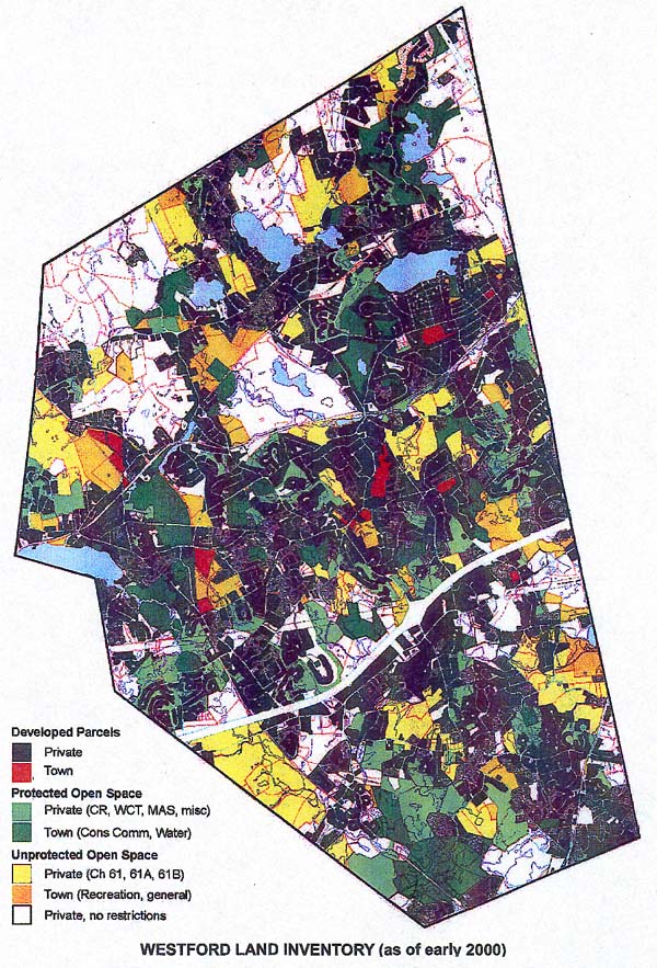
Land InventoryWestford's Open Space Plan was completed and printed in October 2002. This is a very impressive document, and one of its jewels is the Land Inventory Map. It is a map of the whole town, showing the land areas that are owned by the town, and marking the distinctions between conservation lands and other land such as school properties. In addition to town-owned conservation land, several other types of conservation land are shown, including land owned by the Westford Conservation Trust and Massachusetts Audubon. Westford updates the Open Space Plan every five years, following state guidelines. The document is generated by the Conservation Commission, which in this case appointed a committee headed by Margaret Wheeler to draft the actual document. The Land Inventory map shown here was made by committee member Kate Hollister. The Open Space Plan contains an excellent inventory of town land parcels, providing information about the land itself (topography and soils) and current land uses. An inventory of wildlife and plants in Westford is also included. The document also contains a look into the future, making estimates about the construction of additional new houses, and the effects on open space. It includes specific plans for acquisition of open space to keep a balance between developed areas and natural areas. The plan lists all of the sizable privately owned parcels for which conservation acquisition might be considered, such as East Boston Camps along Stony Brook. The original of the Land Inventory map, which is about 3 feet by 4 feet, can be seen in the Fletcher Library. Copies of the Open Space Plan are also available in the Library. See also detailed lists of parcels. |
| Top | Home
| About | Trails
| Gallery | News
| Land | Join
| Contact | Links Copyright © 2003-2005 Westford Conservation Trust. All rights reserved. |